Gracefield, New Zealand facts for kids
Quick facts for kids
Gracefield
|
|
|---|---|
|
Suburb
|
|

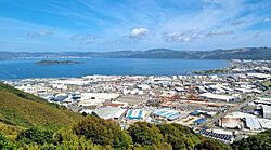
Gracefield (front), Seaview and Wellington Harbour.
|
|
| Country | New Zealand |
| Local authority | Lower Hutt |
| Electoral ward | Harbour |
| Area | |
| • Land | 375 ha (927 acre) |
| Population
(June 2023)
|
|
| • Total | 310 |
|
|
||
Gracefield is a busy area in Lower Hutt City, New Zealand. It's mostly known for its factories and businesses. You can find it at the bottom of the North Island.
For many years, until the 1980s, Gracefield and nearby Petone had big factories. These included places that made wool, fixed trains, put cars together, and processed meat. But when new rules changed how goods were imported, many of these factories closed down.
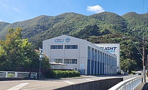
Today, the main offices and labs of Callaghan Innovation are in Gracefield. This is a special group that helps New Zealand businesses create new and exciting things. Their buildings used to belong to a science lab called the Physics and Engineering Laboratory.
Contents
Gracefield's People and Area
Gracefield and the nearby area of Seaview cover about 3.75 square kilometers. As of 2023, around 310 people live here.
| Historical population | ||
|---|---|---|
| Year | Pop. | ±% p.a. |
| 2006 | 75 | — |
| 2013 | 99 | +4.05% |
| 2018 | 141 | +7.33% |
In 2018, 141 people lived in Gracefield. This was a big jump from 2006, when only 75 people lived there. There were 66 homes, with more males than females. The average age was about 44.7 years old.
Most people living in Gracefield are of European background. Some people also identify as Māori or Pasifika. About 15% of the people here were born outside New Zealand.
When asked about religion, most people said they had no religion. Some were Christian, and a few followed other religions like Buddhism.
Learning in Gracefield
Gracefield has its own school called Gracefield School. It's a primary school for students from Year 1 to Year 6. The school was built in 1939 because the area was growing quickly. As of 2024, about 201 students attend the school.
Gracefield's Past
Gracefield is named after Morgan Grace. He was a politician who owned a lot of land here in the 1800s. Back then, Gracefield was mostly farms and fruit orchards. Later, his son, Francis Grace, helped a company buy over 200 acres of land to rent out.
There used to be a short railway line called the Gracefield Branch. It opened in 1929 and was extended into Gracefield in 1943 for freight. This line helped serve the businesses in Seaview. The Gracefield railway yard closed in 2002, and the tracks are now unused.
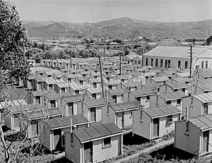
From 1949 to the 1980s, there was a camp for workers near the Wainuiomata Hill Road. The government built it. In the 1950s, about 200 immigrant men lived there. They were working on making the Hutt railway line electric. In the 1970s, the camp housed groups of Tongan workers. These workers came to Lower Hutt for six-month jobs because there weren't enough local workers. The huts were taken down in 1988.
Feltex Factory History
In the mid-1930s, a company called John Grant and Company started a factory in Gracefield Road. This company was part of a bigger group called Felt and Textiles of Australia, known as Feltex. In 1940, Feltex built a huge new factory nearby. They planned to make carpets and all kinds of felt for slippers, hats, and even car parts.
Soon after opening, the factory employed over 200 people. It was making a lot of felt and carpet every week. In the early 2000s, the Feltex factory in Bell Road got even bigger. It became the largest place for spinning yarn in the Feltex group. Feltex was bought by another company in 2006. The Bell Road factory in Gracefield still operates under this brand today.
Griffin's Biscuit Factory
The Griffin's Food Company built a new factory in Gracefield in 1938. The first biscuits were made there in January 1939. The factory was made of strong concrete and had a special roof for good lighting. It was known as 'The Garden Factory' because it had beautiful gardens with lawns, a fountain, and flowers.
The factory had a very long automatic oven, about 100 feet long. It was the first of its kind in the Southern Hemisphere! This oven was used until the factory closed in 2008. In 1939, about two-thirds of the 90 staff were women. They could make 20 tons of biscuits every week. Griffin's closed the factory in 2008, and 200 people lost their jobs. The building later became a factory for recycling plastics.
Science and Innovation at Gracefield
The Department of Scientific and Industrial Research (DSIR) bought land in Gracefield in 1942. They moved their Physical Testing Laboratory into a new building there. This lab had about 80 staff who worked on things like radar and measurements during wartime.
In 1958, the government decided to build a new science branch, the Institute of Nuclear Sciences, also in Gracefield. This is now part of GNS Science. The DSIR was later split up in 1992. Many of its parts became Crown Research Institutes, and some of them are still in Gracefield.
Callaghan Innovation was created in 2013. It was partly formed from Industrial Research Limited, which was a Crown Research Institute. Callaghan Innovation's job is to help New Zealand businesses become more creative and innovative. They set up the 'Gracefield Innovation Quarter'. This place brings together scientists, technicians, and businesses. It has labs, workshops, offices, and a special center for Māori businesses, all on one big site.
Wainuiomata Hill Road
The Wainuiomata Hill Road is the only road that goes to the valley and suburb of Wainuiomata. You can get to the Lower Hutt side of the road from Gracefield using Wainui Road or Gracefield Road. The Hill Road opened in 1860 and has been improved many times since then.
There's a speed camera at the bottom of the hill on Wainui Road, near the old Griffin's factory. It's known for catching drivers who start to speed up for the steep climb or are finishing the downhill stretch. A path for cycling and walking over the hill was finished in 2019. Near the bottom of the Lower Hutt side, a special section for cyclists only splits off and goes downhill, ending at Gracefield Road.
Wainuiomata Tunnel
The Wainuiomata Tunnel was planned to make it easier to get to the Wainuiomata Valley. This was part of a plan to build more homes there in the 1930s. The Lower Hutt side of the tunnel is in Gracefield, at the end of Tunnel Grove. Building started in 1932 but stopped a few years later because there wasn't enough money due to tough economic times.
The tunnel was never opened for cars. It was used briefly by the military during World War II. In 1975, it was sold and finished as a tunnel for pipes and cables. Now, it carries a water pipe, a sewer pipeline, and telecommunications cables. The Greater Wellington Regional Council looks after the tunnel and the water pipe inside it.
Waiwhetū Stream
The Waiwhetū Stream is a small waterway that flows through Gracefield. It drains the eastern side of the Hutt Valley and flows into Wellington Harbour. As the Hutt Valley grew, the stream became more polluted. Parts of the stream were even put into concrete pipes to help stop flooding. The factories in the lower part of the stream made it very polluted. In 2010, it was called one of the most polluted waterways in New Zealand.
People in the community started pushing for a cleanup around 2003. A big project was started to clean the lower parts of the stream. This project finished in June 2010, after 56,000 tonnes of toxic waste were removed. From 2010 to 2011, a community group formed to clean up the upper parts of the stream. Over 10 years, volunteers removed weeds and rubbish from 6 kilometers of the stream. They also planted about 34,000 native plants along the banks.
Gracefield's Weather
| Climate data for Lower Hutt (Gracefield) (1981–2010) | |||||||||||||
|---|---|---|---|---|---|---|---|---|---|---|---|---|---|
| Month | Jan | Feb | Mar | Apr | May | Jun | Jul | Aug | Sep | Oct | Nov | Dec | Year |
| Mean daily maximum °C (°F) | 21.0 (69.8) |
21.3 (70.3) |
19.8 (67.6) |
17.2 (63.0) |
15.0 (59.0) |
12.9 (55.2) |
12.1 (53.8) |
12.8 (55.0) |
14.4 (57.9) |
15.5 (59.9) |
17.1 (62.8) |
19.2 (66.6) |
16.5 (61.7) |
| Daily mean °C (°F) | 17.5 (63.5) |
17.5 (63.5) |
16.1 (61.0) |
13.7 (56.7) |
11.8 (53.2) |
10.0 (50.0) |
9.1 (48.4) |
9.6 (49.3) |
11.2 (52.2) |
12.4 (54.3) |
13.8 (56.8) |
16.0 (60.8) |
13.2 (55.8) |
| Mean daily minimum °C (°F) | 14.0 (57.2) |
13.6 (56.5) |
12.4 (54.3) |
10.2 (50.4) |
8.6 (47.5) |
7.0 (44.6) |
6.1 (43.0) |
6.4 (43.5) |
8.1 (46.6) |
9.3 (48.7) |
10.6 (51.1) |
12.7 (54.9) |
9.9 (49.9) |
| Average rainfall mm (inches) | 53.8 (2.12) |
72.0 (2.83) |
104.5 (4.11) |
57.5 (2.26) |
155.9 (6.14) |
128.1 (5.04) |
168.1 (6.62) |
92.0 (3.62) |
93.8 (3.69) |
82.2 (3.24) |
98.7 (3.89) |
99.5 (3.92) |
1,206.1 (47.48) |
| Source: NIWA | |||||||||||||
 | Kyle Baker |
 | Joseph Yoakum |
 | Laura Wheeler Waring |
 | Henry Ossawa Tanner |


