Grannis, Arkansas facts for kids
Quick facts for kids
Grannis, Arkansas
|
|
|---|---|

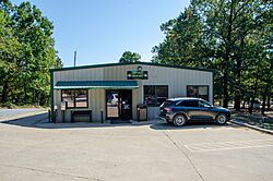
City Hall
|
|

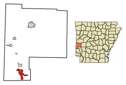
Location of Grannis in Polk County, Arkansas.
|
|
| Country | United States |
| State | Arkansas |
| County | Polk |
| Area | |
| • Total | 7.98 sq mi (20.66 km2) |
| • Land | 7.93 sq mi (20.54 km2) |
| • Water | 0.05 sq mi (0.12 km2) |
| Elevation | 912 ft (278 m) |
| Population
(2020)
|
|
| • Total | 496 |
| • Density | 62.55/sq mi (24.15/km2) |
| Time zone | UTC-6 (Central (CST)) |
| • Summer (DST) | UTC-5 (CDT) |
| ZIP code |
71944
|
| Area code(s) | 870 |
| FIPS code | 05-27970 |
| GNIS feature ID | 2403726 |
Grannis is a small city located in Polk County, Arkansas, in the United States. In 2010, about 554 people lived there.
Grannis is close to the Boggs Springs Youth Encampment. This is a special place where young people from Missionary Baptist churches can go for retreats and camps.
Contents
Where Grannis Is Located
Grannis is found at specific coordinates on a map: 34.238884 degrees north and 94.328404 degrees west.
The United States Census Bureau says that Grannis covers a total area of about 8.6 square miles (22.3 square kilometers). All of this area is land.
Who Lives in Grannis
Population in 2020
According to the 2020 United States census, there were 496 people living in Grannis. These people made up 259 households, and 184 of these were families.
The census also looked at the different groups of people living in Grannis:
| Group | Number | Percentage |
|---|---|---|
| White (not Hispanic) | 292 | 58.87% |
| Native American | 8 | 1.61% |
| Other/Mixed | 28 | 5.65% |
| Hispanic or Latino | 168 | 33.87% |
Schools in Grannis
Grannis is part of the Cossatot River School District.
Back in the 1950s, students from Grannis went to schools in Gillham, which is in Sevier County. Later, Grannis was part of the Wickes School District. This district joined with others to form the Cossatot River district on July 1, 2010.
See also
 In Spanish: Grannis para niños
 | Precious Adams |
 | Lauren Anderson |
 | Janet Collins |

