Granville Lake facts for kids
Quick facts for kids
Granville Lake
ᐅᑳᐏᒥᖨᐦᑳᓈᓂ
okâwimithihkânâni |
|
|---|---|
| Country | |
| Province | |
| Region | Northern Region |
| Census division | 23 |
| Area
(2006)
|
|
| • Total | 2.33 km2 (0.90 sq mi) |
| Population
(2011)
|
|
| • Total | 10 |
| • Density | 4.3/km2 (11/sq mi) |
| Time zone | UTC−6 (CST) |
| • Summer (DST) | UTC−5 (CDT) |
| Postal code |
R0B
|
| Area code(s) | 204 |
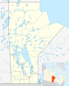
Granville Lake (Cree: ᐅᑳᐏᒥᖨᐦᑳᓈᓂ, okâwimithihkânâni) is a small community in northern Manitoba, Canada. It is located on a piece of land that sticks out into Granville Lake. This lake is part of the large Churchill River system.
The community is mainly a settlement for the Mathias Colomb First Nation. However, most members of this First Nation now live in a nearby town called Leaf Rapids.
Contents
Getting Around Granville Lake
Granville Lake does not have roads that are open all year. This means people cannot drive there easily in every season.
- In the winter, people use ice roads. These are temporary roads built over frozen lakes and rivers.
- In the summer, people travel by using the lake and river system. They often use boats to get around.
Population Changes Over Time
The number of people living in Granville Lake has changed a lot over the years. This is because many people from the community have moved to Leaf Rapids.
Population in 2006
In the 2006 census, Granville Lake had 98 people living there. They lived in 16 homes. This was a big increase of 42% from the year 2001. At that time, the community covered an area of about 2.33 square kilometers (0.90 square miles).
Population in 2011
By the 2011 census, the population of Granville Lake had dropped a lot. Only 10 people were living there. This big change happened because many people from the community moved to Leaf Rapids.
 | Lonnie Johnson |
 | Granville Woods |
 | Lewis Howard Latimer |
 | James West |


