Undine Harbour facts for kids
You may be looking for Undine South Harbour near Ducloz Head, South Georgia
Quick facts for kids Undine Harbour |
|
|---|---|

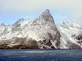
A peak near Cape Paryadin rises above Undine Harbour
|
|
| Location | South Georgia |
| Coordinates | 54°02′24″S 37°57′45″W / 54.0400°S 37.9626°W |
| Type | Bay |
| Ocean/sea sources | South Atlantic Ocean |
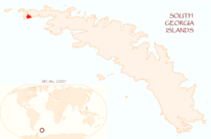
Undine Harbour is a small bay located on the south coast of South Georgia. It's found between two capes, Cape Paryadin and Cape Chaplin. This area is part of the larger Adventure Bay.
Where is Undine Harbour?
Undine Harbour is located near the west end of South Georgia. It sits south of a narrow strip of land called an isthmus. This isthmus separates Undine Harbour from Inner Bay of Elsehul on the north coast.
The bay is positioned between Matthews Point to the west and O'Connor Island to the east. It's the innermost part of Adventure Bay. Adventure Bay stretches from Cape Paryadin in the west to Chaplin Head in the east. Grassolm is an island found within Adventure Bay. Johan Harbour is west of Undine Harbour, while Coal Harbour and Frida Hole are to its east.
How Undine Harbour Was Explored and Named
On March 12, 1823, Captain James Weddell arrived at Adventure Bay, South Georgia. He anchored his two ships, the Jane and the Beaufoy. This was the first time his crew had touched land in five months.
Weddell noted that the land was not very welcoming. However, they found some bitter green herbs. These herbs helped prevent scurvy, a disease caused by lack of vitamin C. They also found many young albatrosses. These birds provided fresh meat, though Weddell said it wasn't as firm as chicken. Weddell's group left in mid-April. They sailed to the Falkland Islands to spend the winter.
Undine Harbour, along with Johan Harbour, Coal Harbour, and Frida Hole, might be part of what Weddell called "Adventure Bay" in 1823. Later, in 1929, the Discovery Investigations (DI) called it "Discovery Bay." The name Undine Harbour became official around 1912. It was named after the sealing ship Undine, which belonged to the Compañía Argentina de Pesca.
Key Features of Undine Harbour
Let's explore some important places around Undine Harbour, moving from west to east.
Matthews Point
Matthews Point forms the western side of the entrance to Undine Harbour. It was mapped between 1926 and 1930 by the Discovery Investigations team. The point is named after L. Harrison Matthews. He was a British zoologist who worked with the Discovery Investigations from 1924 to 1935. He spent time working in South Georgia between 1924 and 1927.
Survey Isthmus
Survey Isthmus is a narrow strip of land. It is about 39 meters (128 feet) high. This isthmus separates Elsehul from Undine Harbour. The name "Survey Isthmus" first appeared on a British Admiralty map in 1931.
Hope Valley
Hope Valley stretches east-northeast for almost 3 nautical miles (5.6 km) from the very end of Undine Harbour. A German expedition led by Ludwig Kohl-Larsen mapped and named it "Tal der Hoffnung" (Valley of Hope) in 1928–29. The English version of this name is now used.
Places West of Undine Harbour
Here are some features located to the west of Undine Harbour, listed from west to east.
Cape Paryadin
Cape Paryadin is the southernmost point on the western tip of South Georgia. It was first discovered in 1775 by a British expedition led by Captain Cook. In 1819, a Russian expedition led by Fabian Gottlieb von Bellingshausen saw the cape again. They named it after Ya. Poryadin, who was a navigator on their ship, the Vostok. The spelling "Paryadin" has been used for a long time.
Andrews Rocks
Andrews Rocks are a small group of rocks. They are about 0.5 nautical miles (0.9 km) east of Cape Paryadin. These rocks have no plants growing on them and are often covered by waves during rough seas. Lieutenant Commander J.M. Chaplin of the ship Discovery likely named them "Andrews Islands" during his survey in 1926. However, the South Georgia Survey (SGS) in 1955–56 said "rocks" was a better description.
Olsen Rock
Olsen Rock is a rock located about 0.5 nautical miles (0.9 km) southeast of Cape Paryadin. It was mapped by Discovery Investigations staff in 1926-27. The SGS surveyed it between 1951 and 1957. The UK Antarctic Place-Names Committee (UK-APC) named it after Søren Olsen. He was a gunner for the South Georgia Whaling Company at Leith Harbour for many years.
Laurie Point
Laurie Point is the eastern end of a small island. This island is close to the shore and marks the southern side of the entrance to Johan Harbour. The SGS surveyed it in 1956–57. The UK-APC named it after A.H. Laurie. He was a scientist with the Discovery Investigations Marine Station at Grytviken in 1930–31. He also worked on the ships William Scoresby and Discovery II.
Saluta Rocks
Saluta Rocks are a group of rocks about 1 nautical mile (1.9 km) east of Laurie Point. Lieutenant Commander J.M. Chaplin of the Discovery probably named them "Mutt and Jeff" during his 1926 survey of the Undine Harbour area. However, the SGS reported in 1955–56 that this name was confusing because there was more than just two rocks. The UK-APC renamed them after the Saluta, a transport ship for the South Georgia Whaling Co.
Johan Harbour
Johan Harbour is a small bay located about 0.5 nautical miles (0.9 km) southwest of Undine Harbour. The name "Johann Harbour" appeared on a map from a 1926-27 survey by Discovery Investigations. The SGS reported in 1957 that "Johan" is the correct spelling. This name is well known to people in the area.
Begg Point
Begg Point forms the northeast side of the entrance to Johan Harbour. The SGS surveyed it in 1956-57. The UK-APC named it after Captain Sinclair Begg. He was a ship master and manager for whaling companies in the region for many years.
Hard Head
Hard Head is a high headland covered in tussock grass. It is about 0.2 nautical miles (0.4 km) south of Matthews Point. It sits on the west side of the path leading into Undine Harbour. Personnel on HMS Owen surveyed it in 1960-61. The UK-APC gave it this descriptive name.
Birdie Rocks
Birdie Rocks are a group of rocks south of Undine Harbour. They are located between Begg Point and Saluta Rocks, off the west end of South Georgia. The name "Birdie Rocks" first appeared on a British Admiralty map in 1929.
Places East of Undine Harbour
Here are some features located to the east of Undine Harbour, listed from west to east.
Bill Inlet
Bill Inlet is a small inlet located just east of Undine Harbour. The name "Bill Inlet" first appeared on a British Admiralty map in 1929.
Coal Island
Coal Island is a small island covered in tussock grass. It has rocks around it and marks the west side of the entrance to Coal Harbour. It's near the west end of South Georgia. Discovery Investigations personnel on the Discovery mapped it between 1926 and 1930. HMS Owen also mapped it in 1960-61. The UK-APC named it in 1963 because of its closeness to Coal Harbour.
Coal Harbour
Coal Harbour is a small bay located about 0.5 nautical miles (0.9 km) east of Undine Harbour. The name "Coaling Harbor" was used around 1912. This suggests that sealers and whalers might have used the bay early on. Discovery Investigations personnel later shortened the name to Coal Harbour.
Frida Hole
Frida Hole is a small bay located about 0.5 nautical miles (0.9 km) southeast of Coal Harbour. It was probably named by early whalers or sealers who used the bay as a safe place to anchor their ships.
Grassholm
Grassholm is an island located about 1 nautical mile (1.9 km) south of Frida Hole. Discovery Investigations personnel, who surveyed this coast in 1926, likely named it "Em Island." However, the SGS reported in 1951–52 that whalers and sealers knew this feature as "Grassholmen," and "Em Island" was not known locally. The current name, Grassholm, has been approved.
Chaplin Head
Chaplin Head is a headland between Undine Harbour and Schlieper Bay. Discovery Investigations mapped it in 1926. At that time, the hill above the headland was called "Sharp Peak." After the SGS surveys from 1951–57, it was renamed Chaplin Head. It is named after Lieutenant Commander John M. Chaplin. He was a survey officer on the Discovery and led a mapping team in South Georgia.
 | George Robert Carruthers |
 | Patricia Bath |
 | Jan Ernst Matzeliger |
 | Alexander Miles |


