- This page was last modified on 17 October 2025, at 10:18. Suggest an edit.
Grays Landing Lock & Dam facts for kids
| Grays Landing Lock and Dam | |
|---|---|
 |
|
| Location | Nicholson Township, Fayette County, Pennsylvania and Monongahela Township, Pennsylvania |
| Coordinates | 39°49′25″N 79°55′19″W / 39.8236°N 79.9219°W |
| Construction began | 1988 |
| Opening date | 1995 |
| Operator(s) | U.S. Army Corps of Engineers, Pittsburgh District |
| Dam and spillways | |
| Impounds | Monongahela River |
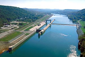
The Grays Landing Lock and Dam is an important structure on the Monongahela River. It used to be called Lock and Dam Number 7. This dam is one of nine similar structures that help boats travel along the river between Pittsburgh, Pennsylvania, and Fairmont, West Virginia.
The U.S. Army Corps of Engineers built and takes care of this dam. It creates a long, calm section of water upstream, about 11.2 miles (18.0 km) long. This calm water reaches all the way to the Point Marion Lock and Dam. You can find Grays Landing Dam at river mile 82 on the Monongahela River.
What is a Lock and Dam?
A lock and dam system helps boats move safely along a river. The dam holds back water to create a deeper, calmer section called a pool. The lock is like a water elevator. It lifts or lowers boats so they can pass from one water level to another.
How Grays Landing Works
At Grays Landing, there is one lock chamber. This chamber is on the left side of the river as you travel downstream. The calm water pool created by the dam is also very important. It provides water for towns and factories nearby.
History of the Dam
The Grays Landing site has had three different dams over time. The very first dam was built in the 1880s. It was made of stone.
Modern Upgrades
In 1923, the old stone dam was replaced with a more modern one. Then, in 1988, construction began on the current structure. This newest version of the Grays Landing Lock and Dam opened in 1995.
