Great Grant Deed facts for kids
The Great Grant Deed, also known as The Great Grant, was a huge land deal. The Cherokee Nation sold a vast amount of land to Richard Henderson and his company. This deal is also called the Louisa purchase or the Transylvania purchase. It happened on March 17, 1775, at Sycamore Shoals on the Watauga River.
The Great Grant covered most of what is now the state of Kentucky. Henderson wanted this land for his new Transylvania Colony. This deal was one of five land sales that took place near present-day Elizabethton, Tennessee. These sales are known as The Watauga Treaties.
One of these deals, the Path Grant Deed, was for land in East Tennessee and Southwest Virginia. This land was important because it allowed people to travel freely into Kentucky. Other deals, like the Charles Robertson Grant Deed and two Jacob Brown Grant Deeds, helped clarify who owned existing settlements in East Tennessee.
These land sales from the Cherokee to American settlers helped the American colonies expand westward. The path from East Tennessee into Kentucky was cleared by Daniel Boone for Richard Henderson. This famous route is known as the Wilderness Road.
Contents
Who Was Involved?
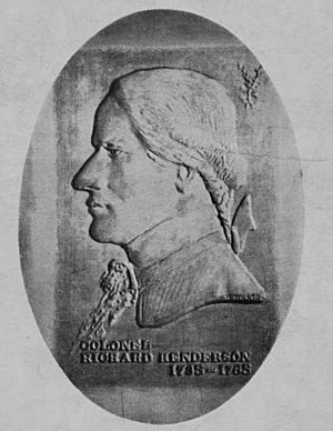
The Buyers: Richard Henderson and Company
The buyers of the land were Richard Henderson and Company, also known as the Transylvania Company. Judge Henderson wanted to open up new areas for people to settle. The company first started as the Louisa Company in North Carolina in August 1774. Later, its name changed to the Transylvania Company in January 1775.
The Transylvania Company was like a real estate group. Nine members invested their own money in this big project. These individuals were Richard Henderson, Thomas Hart, Nathanial Hart, William Johnson, James Hogg, John Lutterell, John Williams, David Hart, and Leonard Henley Bullock. All of them were important property owners from North Carolina.
In late summer 1774, Daniel Boone told Judge Henderson that it was a good time to buy land. So, Judge Henderson, Daniel Boone, and Colonel Nathaniel Hart visited the Cherokee chiefs. They wanted to start talks for buying the large lands in Kentucky.
After this meeting, Cherokee Chief Attacullaculla, a young man, and a woman traveled to North Carolina. They went to see the goods offered for the land sale. The Cherokee representatives approved of the goods. The woman was especially happy with what was presented.
The Sellers: The Cherokee Nation
The sellers of the Great Grant were three Cherokee Chiefs. They acted for the Cherokee Nation. Their names were Alla Cullocullah (also known as Attacullaculla), Oconistoto, and Savanooko. These chiefs were chosen by the warriors and other leaders to represent the entire nation.
Many other Cherokee people were also at the treaty signing. This included Dragging Canoe and Chenosta from the middle Cherokee towns. About 1,200 other Cherokee people also came. They had traveled about 150 miles to Fort Watauga. They came to receive their share of the goods given for the land.
Witnesses said that everything was orderly during the three weeks the Cherokee stayed at Fort Watauga. There was no bad behavior. The Cherokee people were happy with the quality and amount of goods they received.
Disagreement Over the Sale
During the talks, Dragging Canoe, a Cherokee warrior and son of Attacullaculla, warned about the land. He said the land might cause problems. He gave a strong speech to everyone there. He knew that the Cherokee might not truly own all the land they were selling. He thought any sale of it could be challenged.
Just a few days later, Henderson heard about attacks. On April 7, 1775, less than three weeks after the treaty, he learned that Indians had attacked settlers. These settlers were heading to Kentucky, and some were killed. Dragging Canoe had been right. On May 9, 1775, Henderson wrote in his journal about meeting Captain Harrod. Harrod had already settled his company on the Salt River, which was inside the Great Grant lands.
Many others, including both Native Americans and politicians, also spoke out against the treaty.
Was the Deal Legal?
The Transaction Was Not Considered Legal
Today, the Great Grant purchase by Henderson and Company might be seen as a "double scam." Patrick Henry called the deal a "scheme." John Adams also called it a "scheme." This happened after James Hogg asked the Continental Congress to accept Transylvania as the fourteenth colony. Hogg was even chosen as a delegate from the unrecognized Transylvania Colony.
The Virginia House of Delegates canceled the Transylvania Colony and its land claims in November 1778. The main problem was that Henderson had no legal right to buy the land. His actions were illegal. They went against the Royal Decree of 1763, which stopped such purchases. Also, the Virginia Charter claimed all lands within its borders, all the way to the Mississippi River.
Richard Henderson's idea of a Transylvania Colony, which he hoped would be a new government, was stopped. Powerful politicians from Virginia, like George Washington, Sam Adams, and Thomas Jefferson, spoke out against it.
Henderson, however, believed he was right. He studied other land deals to find ways to make his company's purchase legal. He even got legal advice from Lord Mansfield, a famous English judge. Lord Mansfield said that buying land in the American Colonies was like buying land in East India. He said it did not need the King's permission.
Did the Sellers Have the Right to Sell?
There were also problems on the Cherokee side of the deal. The biggest problem was that the Cherokee Nation, represented by Attacullaculla, Oconistoto, and Savanooko, did not actually own all the land they were selling.
At best, the Cherokee Nation's claim to the land between the Kentucky River and the Cumberland River was based on an old claim by Chief Attacullaculla. The deed said the Cherokee had owned the land since the beginning of time. But this was not true. The ownership of any land within the Great Grant was uncertain. This was discussed in several hearings by the Virginia Convention.
One Cherokee Chief, Chenosta, said that the Cherokee had no claim to lands north of the Cumberland River. He said he did not take part in signing those deeds.
Some people believe that Henderson and Company made the deal with the Cherokee for another reason. The northernmost Cherokee towns were only about 50 miles from the Cumberland Gap. This gap controlled the route of the Wilderness Road. So, the Cherokee were, in a way, paid to protect the route into Kentucky.
The lands in the Path Grant were different. Those lands were south of the Cumberland River and Cumberland Mountain. In his speech, Dragging Canoe warned that other Native American groups lived in the lands between the rivers. He said they would fight to keep their lands.
Within one month, "Indians" attacked several groups heading to Kentucky. At least four white settlers were killed.
The Virginia commission claimed the lands, and that ended the matter. The Cherokee's full ownership of all the lands in the deed was never completely settled.
Virginia and North Carolina Canceled the Great Grant
Virginia's Action
Virginia Governor Dunsmore knew about the treaty talks in January 1775. He learned about the Great Grant deal within four days of its signing. This led to a series of hearings by the Virginia Convention. Many people gave statements to explain what happened.
Virginia decided that its constitution required it to protect its territory. The land west of a certain line was Virginia territory. Virginia did not recognize the Transylvania Colony. Virginia officially canceled the Great Grant in December 1778.
North Carolina's Action
North Carolina Governor Martin spoke out against the deal in February 1775. Later, North Carolina agreed with Virginia and the Watauga settlers. They wanted clear boundaries. North Carolina canceled the Transylvania Colony and claimed control over the western territory. This western territory was called the Washington district. It included all of what is now Tennessee. This happened in November 1777.
North Carolina's involvement in the Great Grant was not as big as Virginia's. The lands in question were where the Cumberland River dipped south of the North Carolina/Virginia border. This border had never been properly surveyed. A survey was needed, and Richard Henderson became one of six people to map the line in 1779.
Compensation for Henderson & Co.: The Green River Tract
The Virginia Convention canceled the Great Grant and the Transylvania Colony. But they recognized that Richard Henderson & Co. had made a real effort. So, they decided to give the company some compensation. The Convention granted the company about 200,000 acres of land.
On Wednesday, November 4, 1778, the Virginia House of Delegates:
Resolved, That all purchases of lands made or to be made of the Indians within the chartered bounds of this Commonwealth, as described by the constitution or form of Government, by any private persons not authorized by public authority, are void.
Resolved, That the purchase heretofore made by Colonel Henderson & Co., of the Cherokee Indians is void.
But as said Richard Henderson and Company have been at very great expense in making the said purchase, and in settling the said lands, by which this Commonwealth is likely to receive great advantage by increasing its inhabitants, and establishing a barrier against the Indians, it is just and reasonable to allow the said Richard Henderson & Co. a compensation for their trouble and expense.
A few weeks later, Virginia officially granted the land to Henderson & Co. This land was located on the Ohio and Green Rivers.
Compensation for Henderson & Co: The Powell Valley Tract
Years later, in 1783, North Carolina also decided to compensate Richard Henderson and Co. for their efforts. They gave a grant of 190,000 acres in the Powell Valley. Interestingly, most of this land grant from North Carolina was in what is now Virginia. The grant also included land further west in what is now Anderson County, Tennessee.
The Land's Features
Understanding the Watauga Treaties Lands
To understand the events at Sycamore Shoals, it helps to know about the land itself. A group from North Carolina, led by Richard Henderson, saw a chance to develop lands in the far west, in what would become Kentucky. This group wanted the Great Grant, or the lands of Kentucky. Their desire led to the other four land deals at Sycamore Shoals in March 1775.
The idea of Watauga Treaty lands was not based on political lines on a map. Out west, beyond the tall Appalachian Mountains, there were no political borders. The owners of the lands, the Cherokee and others, did not have maps or lines.
Instead, territories were defined by natural features. These were mountains, ridges, and rivers. The Great Grant, or Transylvania Colony, was mostly defined by rivers: the Kentucky, Cumberland, Tennessee, and Ohio Rivers. Old maps show how these features guided travel westward. These same features were used to describe the boundaries of the Great Grant and Path Grant.
The Cumberland River lands separate from the Kentucky River lands along the top of Cumberland Mountain. These rivers spread out to enclose the large lands of central Kentucky. Even though they start only a few miles apart, their mouths (where they flow into the Ohio River) are 214 miles apart.
New settlers wanted the wide river bottom lands. These lands had rich soil, perfect for clearing and farming. Richard Henderson & Co. wanted the huge potential of central Kentucky. The long river valleys provided easy paths for entering and traveling within these vast new territories.
Description of the Great Grant Lands
There were nine original signed copies of the Great Grant deed, but none are known to exist today. Thomas Price, one of the witnesses, gave a statement to the Virginia Convention in 1776–77. He provided the exact wording of the land description for both the Great Grant and Path Grant deeds.
The Virginia Convention was trying to cancel the Transylvania Colony. They also wanted to decide how to pay Richard Henderson and Company for their efforts. Thomas Price was a well-known Indian trader. He had gone with Richard Henderson to meet the Cherokee chiefs. His statement gave a firsthand account of what truly happened.
The text describing the Great Grant lands was: ". . . all that Tract, Territory or parcel of Land, situated lying & being in North America, on the Ohio River, one of the Eastern Branches of the Mississippi River beginning on the said Ohio River at the Mouth of the Kentucky, Chenosa or what by the English is called Louisa River, from thence running up the said River and the most Northwardly fork of the same to the head of a spring thereof, thence a south east to the top of a ridge of Powells Mountain thence Westwardly along the ridge of the said mountain unto a point from which a Northwest Course will hit or strike the head spring of the most Southwardly branch of the Cumberland River thence down the said River all its waters to the Ohio River thence up the said River as it meanders to the beginning . . ."
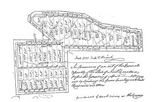
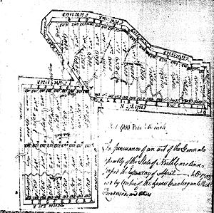
Even though there is no copy of the Great Grant deed, there is a copy of the Path Grant Deed. This companion deed was recorded in 1794. It was signed by the three Cherokee Chiefs, the interpreter Joseph Von, and nine witnesses, including Thomas Price.
It is believed that the Great Grant and Path Grant deeds were almost identical, except for the section describing the land. This makes sense because the buyers, the chiefs, and other parts of the deeds were the same.
The language in both land descriptions is similar. Both deeds also mention the payment. The Path Grant states a payment "of the sum of ten thousand pounds lawful money of Great Britton." The Great Grant's payment is also said to be ten thousand pounds, often described as money or goods. History says the total value of the Watauga Treaty land sales was ten thousand pounds. For this to be true, the ten thousand pounds for the Great Grant and the ten thousand pounds for the Path Grant must be the same payment.
The Great Grant Map
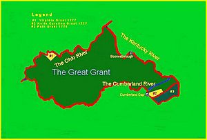
Mapmakers often use the description of the lands between the Cumberland and Kentucky rivers to show the Great Grant lands.
In 1767, John Findley, an Indian trader, visited the West. He traveled through East Tennessee to the Cumberland Gap and explored the Kentucky River. Others, like Daniel Boone, followed him. The Transylvania lands were well known, and their boundaries were accurate.
The map by Nikater, often seen online, correctly shows the land between the rivers as the Great Grant. However, that map does not include a very large southern boundary. This southern part allowed passage into the land through the important Cumberland Gap. The Great Grant land shares a boundary with the lands described in the Path Grant Deed. This shared boundary runs along the top of Powell's Mountain.
The boundaries start at the mouth of the Kentucky River, where it flows into the Ohio River. Then, it follows the Kentucky River and its northern fork to a spring on Cumberland Mountain. From there, a line goes southeast to a point on Powell Mountain. This point is where it meets the Path Grant line. The Great Grant line then follows the Path Grant line along Powell Mountain. It then extends northwesterly to a spot on Cumberland Mountain, west of Cumberland Gap. From that point, water flows north to the Cumberland River. The line then follows the Cumberland River to its mouth at Paducah, where it joins the Ohio River. Finally, the line follows the Ohio River upstream back to the start.
Revolution and the Grant
On April 19, 1775, just one month after the Great Grant was signed, "the shot heard round the world" was fired in Massachusetts. This marked the start of the American Revolution. Later, on July 4, 1776, the United States Declaration of Independence was signed in Philadelphia. On that same day, in Williamsburg, Virginia, the Virginia Convention decided to hear statements about the Transylvania Colony.
Notes on Depositions:
July 4. 1776. Commission to Collect Evidence in behalf of Virginia against persons pretending to have claims for lands within the territory thereof, under deeds and purchases from Indians; & for such purpose given power to summons and examine witnesses under oath and due notice of twenty days being given & c
The American revolt of the thirteen colonies was now fully underway.
The decision to hold the convention hinted at what was to come. July 4, 1776, was a very important day for Thomas Jefferson, who wrote the Declaration. He also played a part in the Virginia Convention. His handwritten notes appear on the document mentioned above.
Richard Henderson and his company had done their research. They sent Daniel Boone to explore and report. Richard Henderson met with Attacullaculla. They asked high British officials about the legality of Crown law. However, they did not foresee the big change that was coming. They did not expect that Crown Law would soon become American law.
Richard Henderson and Company did not foresee a revolution.
 | George Robert Carruthers |
 | Patricia Bath |
 | Jan Ernst Matzeliger |
 | Alexander Miles |


