Jacob Brown Grant Deeds facts for kids
The Jacob Brown Grant Deeds were agreements where the Cherokee Nation sold land to a man named Jacob Brown. These sales are also called the Nolichucky Grants. They happened on March 25, 1775, at a place called Sycamore Shoals near the Watauga River. The land Jacob Brown bought was along the Nolichucky River. He had already been renting some of this land from the Cherokee.
Contents
Where Were the Jacob Brown Grants?
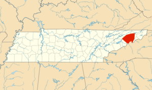
The lands Jacob Brown bought are in what is now East Tennessee, along the Nolichucky River. This land was next to another large area, the Charles Roberson or Watauga Grant, which the Cherokee had sold a few days before.
The Nolichucky Grants were two of five land deals made near today's Elizabethton, Tennessee. These deals happened at Sycamore Shoals on the Watauga River. Together, they are known as The Watauga Treaties. Another important deal was the Path Grant Deed. It covered land in East Tennessee and Southwest Virginia. This land was important for people traveling into Kentucky. The Great Grant Deed was also part of these treaties. The Charles Roberson Grant Deed and the two Jacob Brown Grant Deeds helped make clear who owned existing settlements.
The Watauga Treaties were some of the first agreements between Native Americans and European settlers. They marked the start of American settlers moving westward. Jacob Brown believed that giving land to settlers would help them become free from the British Crown.
Jacob Brown's Early Land Leases
In 1771, Jacob Brown came to the Nolichucky River. He set up a trading post on the northern bank. From here, he traded with the Cherokee people. In 1772, he rented a piece of land from the Cherokee along the Nolichucky River. He paid for this lease with a horse-load of goods. We don't know the exact borders of this rented land.
The lands along the Nolichucky River had rich, fertile soil. Many creeks flowed from the mountains into the river. The valleys were full of wild animals, making it a good hunting area.
Jacob Brown was one of the thirteen original leaders of the Watauga Association. Because he had already leased a large area, his properties were not part of the Charles Robertson Watauga Grant. That deal was made on March 19, 1775, at Sycamore Shoals. Brown had already sold parts of his rented land to other people, like Richard Trivillian.
A lease is a legal agreement. It allows one person to use another person's property for a set time. The lease document describes the property and what is paid for its use. There is no official record of Jacob Brown's lease. At that time, there was no government to enforce such agreements. The Cherokee did not fully understand the legal idea of a "lease." But for the payment, they agreed not to bother Jacob Brown or others living on the land. The closest Cherokee villages were about 95 miles away. However, they still claimed the land for hunting.
The Royal Proclamation of 1763 also played a role. This rule stopped Jacob Brown from buying land beyond the mountains. This rule and questions about who truly owned the land are also discussed in the Great Grant Deed.
Jacob Brown Buys the Land
In March 1775, about 600 settlers and 1,200 Cherokee gathered at Sycamore Shoals. They met to complete land sales. The Cherokee sold land to Richard Henderson & Co. These lands are described in the Path Grant Deed and the Great Grant Deed. They were north of the Holston River in East Tennessee and Southwest Virginia. They also included land in Central Kentucky. The Holston River was generally seen as the border between Virginia and North Carolina.
Jacob Brown took advantage of this large gathering. On March 25, 1775, eight days after the Great Grant was signed, he made his own deal. He negotiated with the Cherokee to buy the Nolichucky River lands outright. This included the land he had been leasing. He paid 10 shillings in addition to his earlier lease payment. The American Revolution against England was starting. So, the rules from the Royal Proclamation of 1763 seemed less important. The original papers for these land sales still exist today.
Jacob Brown's First Land Purchase
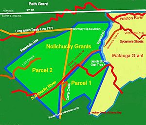
This agreement was made on March 25, 1775. It was between several Cherokee chiefs and Jacob Brown. For ten shillings, Jacob Brown bought land on the Nolichucky River. The description of the land started at the mouth of Great Limestone Creek. It followed the creek to the ridge that separates the Watauga and Nolichucky areas. Then it went up that ridge to the head of Indian Creek, joining the Iron Mountain. From there, it went down the mountain to the Nolichucky River. It crossed the river, including its creeks. Then it went down the side of the Nolichucky Mountain to the mouth of Great Limestone Creek, back to the start.
Many people witnessed this agreement:
| Samuel Crawford | Oconostota | |
| Jesse Denham | The Tenesay Warrior | |
| Moses Crawford | The Bread Slave Catcher | |
| Zachary Isbell | Attacullaculla | |
| Chenesley |
Other warriors who witnessed were Thomas Bulla, Joseph Vann, and Richard Henderson.
Jacob Brown's Second Land Purchase
This was another piece of land on the Nolichucky River. It was below the mouth of Big Limestone Creek, on both sides of the river. It connected to Jacob Brown's first purchase. The description started on the south side of the river, near some old fields. It went north-west to the mouth of Camp Creek. Then it crossed the river and went north-west to the ridge between Lick Creek and Watauga or Holston. It followed that ridge to Jacob Brown's other land. Then it went down the main fork of Big Limestone to its mouth. Finally, it crossed the river to Nolichucky Mountain and followed the mountain back to the start.
The witnesses for these two Jacob Brown purchases were different from those for the Path Grant Deed or the Charles Roberson Grant deed. However, Joseph Vann and Richard Henderson were listed as "Witness the Warriors." Both were present when the Path Grant Deed and Great Grant Deed were signed. Richard Henderson was the buyer of those properties. Joseph Vann, also called "Linquester," was the official translator for the British Crown. He was trusted by both sides. Joseph Vann was part Native American and had worked as an interpreter for the British agent to the Cherokee.
Henderson and Vann's presence suggests that the Brown Grants were indeed signed at Sycamore Shoals. Richard Henderson's diary for March 25, 1775, does not mention him being under an oak tree on the Nolichucky. That location was about twenty miles southwest of Sycamore Shoals.
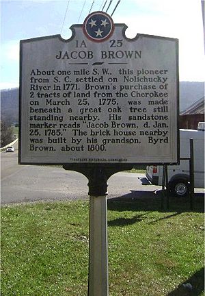
So, the caption on the Tennessee Historical Marker likely mixes up the 1772 lease and the 1775 purchase. The bargaining for the Nolichucky lease in 1772 probably happened under the Big Oak Tree near Jacob Brown's trading post. A document from April 22, 1779, four years after the deed was signed, said the treaty was held at the mouth of Cherokee Creek.
The Jacob Brown Grant Deed was written quickly. After seeing the success of other land deals, especially the Charles Robertson grant, there wasn't time for a detailed survey. All the people involved were gathered and ready to do business. So, the land was described using natural features like mountains, creeks, the Nolichucky River, and a watershed. This was a common way to describe land borders in North Carolina at that time.
Generally, Jacob Brown's properties (both parcel #1 and #2) were bordered on the north by a ridgeline. This ridge includes Fodder Stack and Chimney Top Mountain. This ridge separates the Holston River drainage to the north from the Nolichucky River drainage to the south. The southern border of the grant was the mountains that form the Tennessee/North Carolina border. These mountains separate the Nolichucky River drainage from the French Broad River drainage. To the east, the border was the ridge crest that separates the Nolichucky and Watauga rivers. This line extended south from near Boone Dam to Sam's Gap, which is the head of Indian Creek today. To the west, the border was less clear. It can be seen as a line going north from a high point on the state line above Hot Springs, NC, to the western end of the Chimney Top ridge.
North Carolina's Actions on the Grants
The Great Grant Deed article explains that the land deals at Sycamore Shoals might have been made by sellers who didn't have the full right to sell and buyers who didn't have the full right to buy. For the Jacob Brown deals, this was only partly true. The Cherokee were certainly the original owners of the land along the Nolichucky. However, King George's Royal Proclamation of October 3, 1763, stopped British colonists from settling lands west of the Allegheny Mountains. These lands were considered Indian lands and could not be sold to British colonists.
A disagreement arose from the Great Grant that directly affected Jacob Brown. North Carolina Governor Martin spoke out against the land deals at Sycamore Shoals in February 1775. Later, North Carolina canceled the Transylvania Colony. They claimed control over the western territory, which included all of what is now Tennessee. This happened in November 1777. The Jacob Brown and Watauga Grants of 1775 were ignored by Virginia and North Carolina. These states were negotiating with the Cherokee at the Treaty of Long Island in July 1777.
So, Jacob Brown's land purchases were declared invalid.
By July 1777, the American Revolution was happening. The large areas of the Great Grant and Path Grant were mainly Virginia's concern, with North Carolina being secondary. As mentioned in the Great Grant Deed, Virginia held formal hearings and gathered evidence about these land deals. Virginia officially canceled them in December 1778.
At the Treaty of Long Island on July 20, 1777, Colonel Avery, a commissioner from North Carolina, spoke to the Cherokee and settlers. He explained the problems caused by other land treaties. Selling or leasing land beyond existing treaty lines had led to war and bloodshed for both settlers and Cherokee. Part of the new treaty meant that all such land deals beyond the new border had to stop.
Even though payments for the lands had been made before, and sometimes more than once, Colonel Christian announced a new payment. He said the Cherokee would receive 200 breeding cattle and 100 sheep for their hunting grounds. This payment would reduce their need to hunt. Because of this, Jacob Brown lost ownership of much of the land he had bought at the Watauga Treaty in March 1775.
North Carolina's goal with the treaty was to create peace and set a border. They did not want to take away settled lands that the treaty was meant to protect. So, on November 27, 1778, John Carter of Washington County, now part of North Carolina, ordered a survey. This survey was for 640 acres on the Nolichucky River at the mouth of Cherokee Creek. The county surveyor then surveyed the land. This led to Grant 790 from North Carolina for the 640 acres.
Jacob Brown received two other grants from North Carolina. The first, also in 1779, was Grant 995 for 640 acres. The second was later, for 200 acres, listed as Grant 1156. In total, Jacob Brown received 1,480 acres from North Carolina. These three properties were next to each other along the Nolichucky River. This is how Jacob Brown finally gained official ownership of the lands he had settled on the Nolichucky River.
What Happened Later?
Much later, on May 6, 1784, Jacob Brown asked the State of North Carolina for his money back. He had paid the Cherokee in 1775 for land that North Carolina later took. Then, North Carolina sold this land to the same people Brown had sold it to, but he was never paid.
Jacob Brown Petition to the North Carolina Assembly
May 10, 1784
To the honorable the General assembly of the State of North Carolina
The memorial of Jacob Brown humbly showeth that in the year 1775 your memorialist for the valuable consideration of nearly two thousand pounds specie purchased of the Cherokee Indians a large tract of country adjoining the waters of Nole Chucky; part of which be at different periods sold out to persons desirous of becoming adventurers and settling there, with a desire of reimbursement himself by such sales for the monies he had actually expended in effecting the purchase; but to his great loss And disappointment on the Assembly passing an act granting a right of preemption to the first improvers of the land in that county Those persons who had before purchased of your memorialist not only actually refused to pay him the consideration money back but entered the lands by them formerly purchased of your memorialist in the land office of the state. These together with many other unhappy circumstances oblige your memorialist to make application to your honorable body, and to request you will be pleased to submit the consideration of this matter to aforementioned when he does not doubt to be able to represent his case through them to the assembly In such a point of occur, as to induce the legislature to take same action for his relief and the promise And your petition shall Pray
May 6, 1784 Jacob Brown
Brown knew that Richard Henderson had also asked for money back. Henderson had received a grant of 200,000 acres in 1783 from North Carolina. This was to recognize his efforts in opening up the territory. However, unlike Henderson's request, Jacob Brown's petition was received by the North Carolina Assembly but was turned down.
See also
 | Leon Lynch |
 | Milton P. Webster |
 | Ferdinand Smith |


