
Inagua facts for kids
Quick facts for kids
District of Inagua
|
|
|---|---|
|
District
|
|
 |
|
| Country | |
| Island | Great Inagua |
| Established | 1999 |
| Government | |
| • Type | District Council |
| Area | |
| • Total | 1,679 km2 (648 sq mi) |
| Population
(2008)
|
|
| • Total | ~1,000 |
| • Density | 0.59/km2 (1.5/sq mi) |
| Time zone | UTC−5 (EST) |
| • Summer (DST) | UTC−4 (EDT) |
| Area code(s) | 242 |

Inagua is the southernmost district in the Bahamas. A district is like a special area with its own local government. Inagua is made up of two main islands: Great Inagua and Little Inagua.
Contents
Discover Great Inagua Island
Great Inagua is the third largest island in the Bahamas. It covers about 596 square miles (1,544 km²). This island is located about 55 miles (90 km) from the eastern tip of Cuba.
Geography and Features
Great Inagua is about 55 miles (90 km) long and 19 miles (30 km) wide. The highest point on the island is East Hill, which is 108 feet (33 meters) tall. The island has several lakes inside it. The most famous one is Lake Windsor, also called Lake Rosa. This lake is 12 miles long and covers almost a quarter of the island's middle section.
Matthew Town: The Capital
The main town and only harbour on Great Inagua is Matthew Town. A harbour is a place where ships can safely dock. In 2000, about 969 people lived on Great Inagua. Matthew Town is the center of life and activity for the island.
Amazing Wildlife of Inagua
Inagua is famous for its incredible bird life. There is a very large bird sanctuary in the middle of Great Inagua. This sanctuary is a safe place for many different kinds of birds to live and raise their families.
Home to Thousands of Flamingos
More than 80,000 West Indian Flamingoes live here! These beautiful pink birds are a major attraction. They gather in large groups, creating a stunning sight.
Other Unique Birds
Besides flamingos, you can find many other interesting birds on Inagua. These include the native Bahama Parrot and the tiny Bahama woodstar hummingbird. You might also spot Bahama pintails, Brown pelicans, and different types of herons like Tri-colored herons, Snowy egrets, and Reddish egrets. Other birds include Stripe-headed tanagers, Cormorants, Roseate spoonbills, American kestrels, and Burrowing owls. It's a true paradise for bird watchers!
Images for kids
-
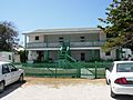
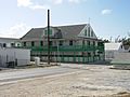
Main Guest House in Matthew Town, Great Inagua
-
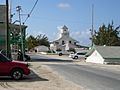
Downtown Matthew Town, Great Inagua
-
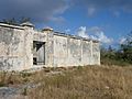
Old disused prison, Matthew Town, Great Inagua
-
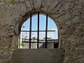
Window in old prison, Matthew Town, Great Inagua
-
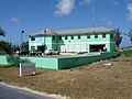
Modern police station, Matthew Town, Great Inagua
-
Grocery store in Matthew Town, Great Inagua
-
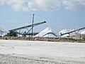
Part of the Morton Salt facilities on the north shore of Great Inagua
-
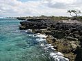
Northern rocky shore of Great Inagua exposing Pleistocene reef limestones


See also
 In Spanish: Inagua para niños
