Green Tree, Pennsylvania facts for kids
Quick facts for kids
Green Tree, Pennsylvania
|
|||
|---|---|---|---|
|
Borough
|
|||

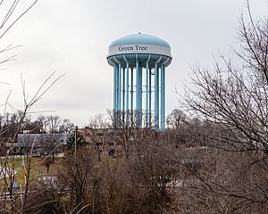
Water tower, visible throughout the borough and surrounding areas
|
|||
|
|||

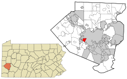
Location in Allegheny County and the state of Pennsylvania.
|
|||
| Country | United States | ||
| State | Pennsylvania | ||
| County | Allegheny County | ||
| Area | |||
| • Total | 2.08 sq mi (5.38 km2) | ||
| • Land | 2.08 sq mi (5.38 km2) | ||
| • Water | 0.00 sq mi (0.00 km2) | ||
| Population
(2020)
|
|||
| • Total | 4,941 | ||
| • Density | 2,381.20/sq mi (919.21/km2) | ||
| Time zone | UTC-5 (EST) | ||
| • Summer (DST) | UTC-4 (EDT) | ||
| FIPS code | 42-31256 | ||
Green Tree is a small town, called a borough, in Allegheny County, Pennsylvania, USA. In 2020, about 4,941 people lived there. It's like a neighborhood right outside the big city of Pittsburgh. You can get to Pittsburgh easily through the Fort Pitt Tunnel.
Contents
History of Green Tree
Green Tree was first settled in 1793. For a long time, it was mostly farmland. Old paintings show lots of farms and even a place where grapes were grown. The community got its name from a local hotel called the Green Tree Hotel. In 1904, a train station opened, which brought more industry and a train yard to the area.
Where is Green Tree?
Green Tree is located at 40°24′54″N 80°2′59″W / 40.41500°N 80.04972°W. It covers about 2.1 square miles (5.4 square kilometers) of land.
Neighboring Communities
Green Tree shares its borders with six other places. Five of these are neighborhoods of Pittsburgh:
- Oakwood and Westwood are to the north.
- Ridgemont is to the northeast.
- Banksville is to the east.
- East Carnegie is to the west.
The sixth border is with Scott Township to the south.
People of Green Tree
The number of people living in Green Tree has changed over the years:
| Historical population | |||
|---|---|---|---|
| Census | Pop. | %± | |
| 1890 | 685 | — | |
| 1900 | 678 | −1.0% | |
| 1910 | 1,143 | 68.6% | |
| 1920 | 1,043 | −8.7% | |
| 1930 | 1,457 | 39.7% | |
| 1940 | 1,880 | 29.0% | |
| 1950 | 2,818 | 49.9% | |
| 1960 | 5,226 | 85.5% | |
| 1970 | 6,441 | 23.2% | |
| 1980 | 5,722 | −11.2% | |
| 1990 | 4,905 | −14.3% | |
| 2000 | 4,719 | −3.8% | |
| 2010 | 4,432 | −6.1% | |
| 2020 | 4,941 | 11.5% | |
| Sources: | |||
In 2000, there were 4,719 people living in Green Tree. Most people (96.21%) were White. There were also smaller groups of African American (0.53%) and Asian (1.95%) residents. About 0.66% of the population was Hispanic or Latino. Many families in Green Tree have German, Irish, Italian, Polish, or English backgrounds.
The average age in Green Tree in 2000 was 45 years old. About 19.4% of the people were under 18. Most households were married couples living together.
Economy and Businesses
Green Tree is home to some important businesses and government offices:
- Wexford Health Sources has its main office in Foster Plaza Two. They work in healthcare.
- The U.S. Department of the Interior has its Appalachian Regional Coordination Center here. This includes the Pittsburgh Field office and the National Mine Map Repository, which keeps maps of old mines.
Famous People from Green Tree
Even though they were born in nearby Pittsburgh, two well-known people have connections to Green Tree:
- Ron Paul is a former U.S. Congressman. He also ran for president in 2012.
- Zachary Quinto is an actor. You might know him from the Star Trek movies or the TV show Heroes.
See also
 In Spanish: Green Tree para niños
 | Kyle Baker |
 | Joseph Yoakum |
 | Laura Wheeler Waring |
 | Henry Ossawa Tanner |


