Greenhorn Valley facts for kids
Quick facts for kids Greenhorn Valley |
|
|---|---|

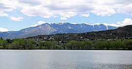
Looking across Lake Beckwith towards Greenhorn Mountain
|
|
| Floor elevation | 1,784 m (5,853 ft) |
| Geography | |
| Location | Pueblo County, Colorado |
| Country | United States |
| Topo map | Colorado City Rye |
| Traversed by | Colorado State Highway 165 |
| River | Greenhorn Creek |
The Greenhorn Valley is a beautiful area in southern Pueblo County, Colorado. It sits just east of the tall Greenhorn Mountain. This valley is home to the towns of Colorado City and Rye.
Colorado State Highway 165 runs through the valley. This road is part of the Frontier Pathways Scenic Byway, which is a special route known for its pretty views. Interstate 25 marks the eastern edge of the valley.
Contents
Exploring Greenhorn Valley's Geography
The western part of Greenhorn Valley touches the San Isabel National Forest. This is a large area of protected land with many trees and wildlife.
Lake Beckwith: A Fun Place to Visit
Lake Beckwith is a popular spot in the valley. It's a reservoir managed by the Colorado City Metropolitan District. It's also a state wildlife area looked after by Colorado Parks and Wildlife. You can go fishing, walking, or canoeing here.
Greenhorn Mountain: A Valley Landmark
Greenhorn Mountain stands tall at 12,346 feet (3,763 meters). It overlooks the valley from the west. This mountain is a major landmark and can be seen from many places in the valley.
Schools in Greenhorn Valley
The Greenhorn Valley Schools district serves the students in this area. There are three schools for different age groups. These include Rye Elementary School, Craver Middle School, and Rye High School.
 | Kyle Baker |
 | Joseph Yoakum |
 | Laura Wheeler Waring |
 | Henry Ossawa Tanner |


