Ground Equipment Facility QRC facts for kids
Quick facts for kids Ground Equipment Facility QRCBenton Air Force Station |
|
|---|---|
| Part of 1975: Federal Aviation Administration 1968: 1951: |
|
| Located at Red Rock Mountain, Colley Township, Sullivan County, Pennsylvania (eponym: the nearby Town of Benton) |
|

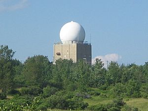
The AN/FPS-67B radar antenna is beneath a radome (white) and uses the preceding AN/FPS-35 tower (5-story building).
|
|
| Coordinates | 41°21′25″N 076°17′25″W / 41.35694°N 76.29028°W (QRS) 41°21′30″N 076°17′40″W / 41.35833°N 76.29444°W (AFS) |
| Type | Common Air-Route Surveillance Radar (CARSR) site |
| Code | QRC: Federal Aviation Administration J-tbd: c. 2002 Joint Surveillance System Z-30: 1963 July 31 SAGE radar network P-30: 1952 Permanent System |
| Site information | |
| Controlled by | 1975: Federal Aviation Administration
1974:: 648th Radar Squadron 1950: 648th Aircraft Control and Warning Squadron |
| Site history | |
| Built | 1950-1 |
The Ground Equipment Facility QRC is a radar station used by the Federal Aviation Administration (FAA). It was once a very important military radar station called Benton Air Force Station during the Cold War. Its job was to help control and warn about aircraft, covering a huge area from Massachusetts to southern Virginia.
Today, the FAA facility and the land where the Air Force Station used to be are part of Ricketts Glen State Park.
Contents
History of the Radar Station
The story of this radar station began on April 30, 1948. A military unit called the 648th Aircraft Control and Warning Squadron was formed. They first operated a temporary radar station in New York.
In December 1949, the squadron moved to Fort Indiantown Gap. Then, around January 1, 1951, they started using a radar at a new location. Construction for the main site began in 1950 and was finished on September 21, 1951. The radar and operations officially moved to Ricketts Glen State Park, Pennsylvania, by February 1, 1952.
Benton Air Force Station's Role
On December 1, 1953, the radar station at Ricketts Glen State Park was officially named Benton Air Force Station. At first, it sent tracking information to a manual control center. This center helped guide planes.
Later, in 1959, Benton's data was sent to a new, computerized system called SAGE (Semi-Automatic Ground Environment). This system used powerful computers to track aircraft. In 1960, special equipment was installed to send data to these computers.
In 1961, a new, large radar called the AN/FPS-35 became active at Benton. This radar was very heavy and had a distinctive red and white checkerboard pattern. A new building for radio communication was also built nearby. By 1963, Benton AFS also had other radars to help find the height of aircraft.
Working with the FAA and Detecting Nuclear Events
By the end of 1963, Benton Air Force Station was used by both the U.S. Air Force and the FAA. By 1967, it was helping with air traffic control for New York.
Benton AFS also played a role in a system to detect nuclear events. In 1962, a special contract was made to test a nuclear detection system. By July 1, 1964, Benton AFS became a main center for this system, receiving information from sensors in different locations.
The FPS-35 radar at Benton was even tested in 1962 to see if it could track missile launches from Cape Canaveral. It had some ability to do so. Benton AFS also had a backup system to guide interceptor planes.
An interesting story from before 1974: the radar "scopes would light up like light bulbs" almost every morning. This was caused by a noisy UHF TV tuner in the area. It turned out someone was using it to watch a "soap opera on one of the local channels"!
Becoming an FAA Facility
On November 22, 1974, it was announced that many Air Defense stations would close. The radar facility at Benton Air Force Station was transferred to the Federal Aviation Administration on June 30, 1975. The military squadron there was also closed on that date.
Benton became an auxiliary radar for Wilkes-Barre/Scranton International Airport. Other buildings and barracks were given to the Red Rock Job Corps Center in 1978. After 2001, the FAA site became part of the Joint Surveillance System. Today, the radar there is called a Common Air-Route Surveillance Radar (CARSR).
Military Assignments
Benton AFS and its squadron were part of several larger military units over the years. These units were part of the Air Defense Command (later called Aerospace Defense Command).
- 503d Aircraft Control and Warning Group, 1 January 1951
- 26th Air Division, 6 February 1952
- 4710th Defense Wing, 10 February 1953
- 4709th Defense Wing, 30 June 1953
- 4707th Air Defense Wing, 8 July 1956
- 4622d Air Defense Wing, 18 October 1956
- Boston Air Defense Sector, 8 January 1957
- Syracuse Air Defense Sector, 15 August 1958
- Boston Air Defense Sector, 4 September 1963
- 35th Air Division, 1 April 1966
- 21st Air Division, 19 November 1969 – 30 June 1975

