Grovertown, Indiana facts for kids
Quick facts for kids
Grovertown, Indiana
|
|
|---|---|
| Country | United States |
| State | Indiana |
| County | Starke |
| Township | Oregon |
| Elevation | 725 ft (221 m) |
| Time zone | UTC-6 (Central (CST)) |
| • Summer (DST) | UTC-5 (CDT) |
| ZIP code |
46531
|
| Area code(s) | 574 |
| GNIS feature ID | 449664 |
Grovertown is a small place in Starke County, Indiana. It is also known as Grover Town or Grovestown. Grovertown is an unincorporated community. This means it does not have its own local government like a city or town. Instead, it is part of a larger area called Oregon Township.
A Look at Grovertown's Past
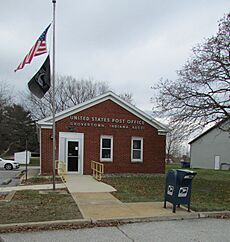
Grovertown was first planned out in 1858. This means people decided where streets and buildings would go. A year later, in 1859, Grovertown got its own post office. This post office is still open today and uses the ZIP code 46531.
A very important event for Grovertown was the arrival of the Pittsburg, Ft. Wayne & Chicago Railroad. This railroad ran right through the community. Railroads were like major highways in the past. They helped towns grow by bringing people and goods. At one time, about 200 people lived in Grovertown.
Where is Grovertown Located?
Grovertown is in the southeastern part of Oregon Township. It is located in Starke County. You can find Grovertown along State Road 23. This road is northeast of Knox, which is the main town, or county seat, of Starke County.
 | Roy Wilkins |
 | John Lewis |
 | Linda Carol Brown |


