Guadalupe, Peru facts for kids
Quick facts for kids
Guadalupe
|
|||
|---|---|---|---|
|
Town
|
|||

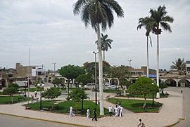
Main Square of Guadalupe
|
|||
|
|||
| Country | |||
| Region | La Libertad | ||
| Province | Pacasmayo | ||
| District | Guadalupe | ||
| Elevation | 92 m (302 ft) | ||
| Population | |||
| • Estimate
(2015)
|
43,356 | ||
| Time zone | UTC-5 (PET) | ||
Guadalupe (in the old Mochica language: Namæl) is a city in northern Peru. It is the main city of the Guadalupe district in the La Libertad region.
This city is about 127 kilometers (about 79 miles) north of Trujillo. Guadalupe is mostly known as a farming center. It is located in the Jequetepeque Valley, which is a fertile area.
Education in Guadalupe
Guadalupe is home to a small campus of the Universidad Nacional de Trujillo. This university campus is located on the northeast side of the city. It provides educational opportunities for students in the area.
Guadalupe's Climate
The climate in Guadalupe is generally warm. It has different temperatures and rainfall throughout the year. Knowing the climate helps us understand the environment of the city.
| Climate data for Guadalupe (Talla), elevation 117 m (384 ft), (1991–2020) | |||||||||||||
|---|---|---|---|---|---|---|---|---|---|---|---|---|---|
| Month | Jan | Feb | Mar | Apr | May | Jun | Jul | Aug | Sep | Oct | Nov | Dec | Year |
| Mean daily maximum °C (°F) | 29.5 (85.1) |
30.2 (86.4) |
30.3 (86.5) |
29.4 (84.9) |
27.8 (82.0) |
25.8 (78.4) |
24.9 (76.8) |
24.8 (76.6) |
25.6 (78.1) |
26.3 (79.3) |
26.9 (80.4) |
28.2 (82.8) |
27.5 (81.4) |
| Mean daily minimum °C (°F) | 20.2 (68.4) |
21.2 (70.2) |
20.8 (69.4) |
19.1 (66.4) |
17.3 (63.1) |
15.6 (60.1) |
14.4 (57.9) |
14.2 (57.6) |
14.7 (58.5) |
15.4 (59.7) |
16.1 (61.0) |
18.3 (64.9) |
17.3 (63.1) |
| Average precipitation mm (inches) | 6.5 (0.26) |
14.2 (0.56) |
17.6 (0.69) |
3.5 (0.14) |
0.9 (0.04) |
0.2 (0.01) |
0.0 (0.0) |
0.2 (0.01) |
0.4 (0.02) |
1.4 (0.06) |
1.3 (0.05) |
4.9 (0.19) |
51.1 (2.03) |
| Source: National Meteorology and Hydrology Service of Peru | |||||||||||||
See also
 In Spanish: Guadalupe (Perú) para niños
 | Precious Adams |
 | Lauren Anderson |
 | Janet Collins |


