Guamá, Cuba facts for kids
Quick facts for kids
Guamá
|
|
|---|---|
 |
|

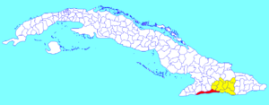
Guamá municipality (red) within
Santiago Province (yellow) and Cuba |
|
| Country | Cuba |
| Province | Santiago de Cuba |
| Seat | Chivirico |
| Area | |
| • Total | 964.6 km2 (372.4 sq mi) |
| Elevation | 20 m (70 ft) |
| Population
(2022)
|
|
| • Total | 34,296 |
| • Density | 35.5546/km2 (92.086/sq mi) |
| Time zone | UTC-5 (EST) |
| Area code(s) | +53-226 |
| Website | https://www.guama.gob.cu/ |
Guamá is a special area in the Santiago de Cuba Province of Cuba. It's called a municipality, which is like a county or district. The main town in Guamá is named Chivirico.
This place got its name from a brave Taíno leader called Guamá. He was a cacique, which means a chief. Guamá led a fight against the Spanish in the 1530s.
Contents
Where is Guamá Located?
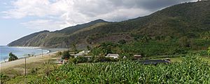
Guamá is in the southwest part of the Santiago de Cuba province. It has a long coastline along the Caribbean Sea, west of the city of Santiago de Cuba.
Towns and Villages in Guamá
Besides Chivirico, many smaller villages are part of Guamá. These include Aserradero, Buey Cabón, and La Plata. Other villages are La Mula, Las Cuevas, and Uvero.
Cuba's Highest Peak
Did you know that the highest mountain in all of Cuba is in Guamá? It's called Pico Turquino. This tall peak is a famous landmark in the area.
How Many People Live in Guamá?
In 2022, about 34,296 people lived in the municipality of Guamá.
Size of the Area
Guamá covers a total area of about 965 square kilometers (373 square miles). This means there are about 36.8 people living in each square kilometer.
Getting Around Guamá
A main highway runs along the entire coast of Guamá. This road is called the "Circuito Sur de Oriente" (CSO). People also call it the Granma Road. It stretches along Cuba's southern coast, connecting Santiago de Cuba to the Granma Province.
See also
 In Spanish: Guamá (Cuba) para niños
 | Audre Lorde |
 | John Berry Meachum |
 | Ferdinand Lee Barnett |

