Guasdualito facts for kids
Quick facts for kids
Guasdualito
|
|
|---|---|
 |
|
| Country | |
| State | Apure |
| Municipality | Páez Municipality |
| Founded | 1770/1 |
| Elevation | 125 m (410 ft) |
| Population | |
| • Total | 105,000 |
| • Demonym | Guasdualiteño/a |
| Time zone | UTC−4 (VET) |
| Postal code |
5063
|
| Area code(s) | 0278 |
| Climate | Aw |
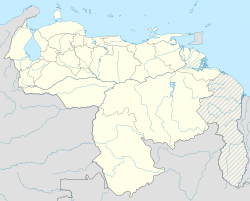
Guasdualito is a city located in the Apure State in southern Venezuela. It's an important place, sometimes called an "episcopal see," which means it's where a bishop has his main church.
About Guasdualito
Guasdualito is the main city of the Páez Municipality. It is also part of a special area called the Distrito Especial Alto Apure.
This city is very important for trade. It sits right on the border between Venezuela and the city of Arauca in Colombia. This makes it a busy place for buying and selling goods. Guasdualito is also a major center for petroleum (oil) in its region.
Around 100,000 people lived in Guasdualito in 2014.
Guasdualito's Weather
Guasdualito has a tropical savanna climate. This means it's always hot there. It also has clear wet and dry seasons each year.
The wet season in Guasdualito lasts from April to November. The most rain falls in May, June, and July. The dry season is shorter, from December to March.
The hottest months are from February to April. During this time, the average high temperature is about 34 °C (93 °F). The coolest period is from June to August, with average highs around 30 °C (86 °F).
| Climate data for Guasdualito (1991–2020) | |||||||||||||
|---|---|---|---|---|---|---|---|---|---|---|---|---|---|
| Month | Jan | Feb | Mar | Apr | May | Jun | Jul | Aug | Sep | Oct | Nov | Dec | Year |
| Record high °C (°F) | 36.9 (98.4) |
37.8 (100.0) |
39.6 (103.3) |
39.0 (102.2) |
38.4 (101.1) |
39.1 (102.4) |
36.4 (97.5) |
36.1 (97.0) |
35.6 (96.1) |
38.3 (100.9) |
38.3 (100.9) |
38.5 (101.3) |
39.6 (103.3) |
| Mean daily maximum °C (°F) | 33.3 (91.9) |
34.5 (94.1) |
34.8 (94.6) |
33.4 (92.1) |
31.8 (89.2) |
30.4 (86.7) |
30.2 (86.4) |
30.8 (87.4) |
31.5 (88.7) |
31.8 (89.2) |
31.6 (88.9) |
32.2 (90.0) |
32.2 (90.0) |
| Daily mean °C (°F) | 25.9 (78.6) |
26.9 (80.4) |
27.6 (81.7) |
27.0 (80.6) |
26.2 (79.2) |
25.5 (77.9) |
25.2 (77.4) |
25.5 (77.9) |
25.9 (78.6) |
26.1 (79.0) |
26.0 (78.8) |
25.9 (78.6) |
26.1 (79.0) |
| Mean daily minimum °C (°F) | 21.4 (70.5) |
22.3 (72.1) |
23.0 (73.4) |
23.3 (73.9) |
23.1 (73.6) |
22.6 (72.7) |
22.4 (72.3) |
22.5 (72.5) |
22.7 (72.9) |
22.9 (73.2) |
22.8 (73.0) |
22.1 (71.8) |
22.6 (72.7) |
| Record low °C (°F) | 16.8 (62.2) |
17.2 (63.0) |
18.6 (65.5) |
18.8 (65.8) |
20.5 (68.9) |
20.5 (68.9) |
20.1 (68.2) |
20.3 (68.5) |
18.2 (64.8) |
18.5 (65.3) |
18.2 (64.8) |
18.0 (64.4) |
16.8 (62.2) |
| Average precipitation mm (inches) | 14.7 (0.58) |
25.6 (1.01) |
58.4 (2.30) |
160.1 (6.30) |
270.1 (10.63) |
304.1 (11.97) |
289.8 (11.41) |
210.1 (8.27) |
177.0 (6.97) |
161.4 (6.35) |
110.0 (4.33) |
29.2 (1.15) |
1,810.5 (71.28) |
| Average precipitation days (≥ 1.0 mm) | 1.1 | 2.1 | 4.0 | 10.4 | 15.1 | 18.3 | 17.8 | 15.1 | 11.8 | 11.3 | 7.0 | 3.3 | 117.3 |
| Source: NOAA | |||||||||||||
Important Buildings
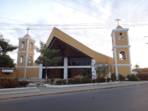
The Our Lady of Mount Carmel Cathedral is a very important church in Guasdualito. It is dedicated to the Virgin of Mercy. Since December 2015, it has been the main church for the Roman Catholic Diocese of Guasdualito. This means it's where the local bishop has his official seat.
See also
 In Spanish: Guasdualito para niños
 | Delilah Pierce |
 | Gordon Parks |
 | Augusta Savage |
 | Charles Ethan Porter |


