Hackney, Kansas facts for kids
Quick facts for kids
Hackney, Kansas
|
|
|---|---|

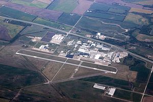
Aerial view of Hackney, including Strother Field industrial park and airport
|
|

|
|
| Country | United States |
| State | Kansas |
| County | Cowley |
| Elevation | 1,099 ft (335 m) |
| Time zone | UTC-6 (CST) |
| • Summer (DST) | UTC-5 (CDT) |
| Area code | 620 |
| FIPS code | 20-29375 |
| GNIS ID | 470349 |
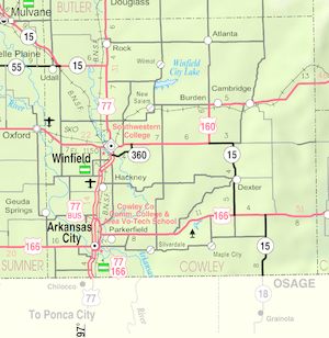
Hackney is a small, unincorporated community located in Cowley County, Kansas, United States. An "unincorporated community" means it's a place where people live, but it doesn't have its own local government like a city or town.
A Look Back in Time
The community of Hackney was named after William P. Hackney. He was a well-known lawyer and politician from Cowley County, Kansas.
Long ago, Hackney was an important stop for trains. It was a "station and shipping point" on the Atchison, Topeka and Santa Fe Railway. This means it was a place where trains stopped to pick up and drop off goods.
Hackney even had its own post office! It opened on March 31, 1894. However, it closed down on February 15, 1924.
In the early 1940s, an airport was built near Hackney. During World War II, the United States Army Air Forces used this airport. It was a training airfield where pilots learned to fly. Today, this airport is known as Strother Field. It is also home to the Strother Field Industrial Park, where many businesses are located.
Learning in Hackney
Students who live in the Hackney community attend public schools. These schools are part of the Winfield USD 465 public school district.
 | Shirley Ann Jackson |
 | Garett Morgan |
 | J. Ernest Wilkins Jr. |
 | Elijah McCoy |


