Hackney Canal facts for kids
Quick facts for kids Hackney Canal |
|
|---|---|

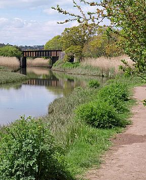
The railway bridge over the entrance to the canal. The lock was just beyond the bridge.
|
|
| Specifications | |
| Locks | 1 |
| Status | mostly filled in |
| History | |
| Date of act | Privately built |
| Date of first use | 1843 |
| Date closed | 1928 |
| Geography | |
| Start point | Hackney Clay Cellars |
| End point | River Teign |
The Hackney Canal was a short waterway in Devon, England. It connected the Hackney Clay Cellars to the River Teign. A person named Lord Clifford built it privately in 1843. The canal was used to transport ball clay, which is a special type of clay used to make pottery. It stopped being used in 1928 because trucks on roads took over its job.
Contents
History of the Hackney Canal
The area north of the River Teign was very important for ball clay mining. This was especially true in the 1700s and 1800s. Many of these clay mines belonged to Lord Clifford. He lived at Ugbrooke House.
Workers would take the clay to Hackney Clay Cellars to dry it. Then, they moved it to Teignmouth using packhorses. From Teignmouth, the clay was loaded onto ships called coasters. These ships would deliver the clay to places that made pottery.
However, loading the ships was hard. The river at Teignmouth had strong tides. This made it difficult to load the heavy clay onto the boats.
Building the Canal
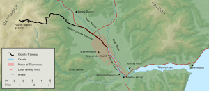
To make things easier, Lord Clifford decided to build a canal. This canal would link the clay pits directly to the River Teign. The canal's end point was near the road between Newton Abbot and Kingsteignton.
The Hackney Canal opened on March 17, 1843. It was about 1 kilometer (0.6 miles) long. It had one lock where it met the river. A lock is like a water elevator for boats. This lock was 33 meters (108 feet) long and 4.2 meters (14 feet) wide. The water inside was about 1.1 meters (3.75 feet) deep.
The boats used on the canal were made of wood. They were about 15 meters (50 feet) long and 4.2 meters (14 feet) wide. They had a flat bottom and a rounded front. These boats had a single square sail, like old Viking ships. They were similar to boats called Humber keels. The lock was big enough for two boats to use it at the same time.
Railway Bridge and Changes
In 1844, the South Devon Railway Company built a bridge. This bridge went over the canal. The port of Teignmouth hired an engineer named John Rennie the Younger. His job was to make sure the railway bridge was big enough. This way, boats could still pass under it easily.
Later, in 1858, a new railway line was planned. It was called the Newton and Moretonhampstead Railway. This company was later renamed. The railway company bought another nearby canal, the Stover Canal, in 1862.
People who used the canals wondered if the railway company would sell them. There is no clear record that the railway company bought the Hackney Canal. But they did receive letters asking about its future. The railway company said they had not decided anything yet.
Why the Canal Closed
The Hackney Canal stopped being used in 1928. The canal's end point was right next to a main road. When motor trucks became common, they could carry the clay much faster. So, the canal was no longer needed.
For a short time in 1954, a company used the canal basin to build yachts. But they also started using trucks to move their finished boats. They soon moved their business to Brixham.
In 1955, a wall was built around the lock. This was because high tides from the river broke through. The water flooded the nearby Newton Abbot Racecourse.
Exploring the Canal's Route
The canal started near the Kingsteignton road. This area had a basin, which is like a wide pool for boats. There were also buildings on both sides. The basin was later filled in so trucks could turn around. The buildings were used as a car body workshop for many years.
Most of these buildings were torn down in 2001. This happened during a project to redevelop the area. Only one building, which was a grade II listed structure, remained.
The path next to the canal, called the tow-path, was on the north side. Water flowed into the canal from a small channel called a leat. This leat went under the tow-path. It also crossed over a drainage ditch using a small bridge, called an aqueduct.
South of the canal's start was Newton Abbot Potteries. This factory made bricks and pipes. The canal then turned southeast. It went in a straight line across what is now part of Newton Abbot racecourse.
In 1969, the race track ended near the canal. But by 1989, the track was made longer. It now covers where the canal used to be. A drainage ditch in the area shows where the canal once was. This ditch was on the west side of the canal before it was filled in.
Just past the race track's second crossing, you can find the remains of the lock. There is also the wall that stops the River Teign from flooding the area. The canal's route then turns east. It goes under the railway line. Finally, it joins the Hackney channel of the River Teign.
Places of Interest Along the Canal
| Point | Coordinates (Links to map resources) |
OS Grid Ref | Notes |
|---|---|---|---|
| Hackney Clay Cellars | 50°32′34″N 3°35′54″W / 50.5429°N 3.5983°W | SX868726 | Northern end of the canal |
| Newton Abbot racecourse crossing | 50°32′27″N 3°35′42″W / 50.5409°N 3.5950°W | SX870724 | North side of the racecourse |
| Site of lock | 50°32′19″N 3°35′31″W / 50.5386°N 3.5919°W | SX872721 | Where the lock used to be |
| Junction with Hackney Channel | 50°32′20″N 3°35′20″W / 50.5389°N 3.5888°W | SX875722 | Where the canal met the River Teign |
 | Stephanie Wilson |
 | Charles Bolden |
 | Ronald McNair |
 | Frederick D. Gregory |


