Hale Glacier facts for kids
Quick facts for kids Hale Glacier |
|
|---|---|

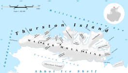
Map of Thurston Island
|
|
| Location | Ellsworth Land |
| Coordinates | 72°13′S 100°33′W / 72.217°S 100.550°W |
| Length | 6 nautical miles (11 km; 6.9 mi) |
| Thickness | unknown |
| Terminus | Peacock Sound |
| Status | unknown |
The Hale Glacier is a large river of ice in Antarctica. It is about 6 nmi (11 km) long. This glacier is found just east of Mount Simpson on Thurston Island. It flows southwest into the Abbot Ice Shelf in an area called Peacock Sound.
Discovering and Naming the Glacier
Scientists first mapped Hale Glacier from air photos. These pictures were taken by the U.S. Navy Squadron VX-6 in January 1960. A special group called the Advisory Committee on Antarctic Names (US-ACAN) officially named the glacier. They named it after Lieutenant Bill J. Hale. He was a helicopter pilot for the U.S. Navy. Lieutenant Hale flew important exploration trips to Thurston Island in February 1960. He was flying from the ship USS Burton Island.
Gould Knoll: A Nearby Landmark
Near the Hale Glacier, there is a rocky hill called Gould Knoll. This knoll is mostly covered in ice. It sits on the eastern edge of the glacier. This is where the glacier flows into the Abbot Ice Shelf. Gould Knoll was named by the US-ACAN. It honors William G. Gould. He was a specialist at the National Oceanic and Atmospheric Administration. From the 1960s to the mid-1990s, Mr. Gould helped save satellite images of the world. These images included important maps of Antarctica.


