Hallein District facts for kids
Quick facts for kids
Hallein District
Bezirk Hallein
|
|
|---|---|
| Country | Austria |
| State | Salzburg |
| Number of municipalities | 13 |
| Area | |
| • Total | 668.31 km2 (258.04 sq mi) |
| Population
(2001)
|
|
| • Total | 54,282 |
| • Density | 81.2228/km2 (210.366/sq mi) |
| Time zone | UTC+01:00 (CET) |
| • Summer (DST) | UTC+02:00 (CEST) |
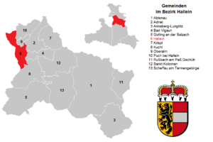
Hallein is an administrative district in the state of Salzburg, Austria. It is also known as the Tennengau region. The main town and administrative center of the district is Hallein.
About Hallein District
An administrative district in Austria is like a county or a region. It helps organize local government. The Hallein District covers an area of about 668 square kilometers. In 2001, about 54,282 people lived here.
The district is located in the beautiful state of Salzburg. It has many different communities, from busy towns to smaller villages.
Towns and Municipalities
The Hallein District is divided into 13 different communities. These include one main town and four market towns. Each community has its own local government.
Towns
- Hallein (18,399 people)
Market towns
Market towns are communities that historically had the right to hold markets.
- Abtenau (3,324 people)
- Golling an der Salzach (3,903 people)
- Kuchl (6,431 people)
- Oberalm (3,844 people)
Municipalities
These are smaller communities or villages.
- Adnet (3,324 people)
- Annaberg-Lungötz (2,296 people)
- Bad Vigaun (1,885 people)
- Krispl (849 people)
- Puch bei Hallein (4,088 people)
- Rußbach am Paß Gschütt (803 people)
- Sankt Koloman (1,497 people)
- Scheffau am Tennengebirge (1,292 people)
(Population numbers are from May 15, 2001)
See also
 In Spanish: Distrito de Hallein para niños


