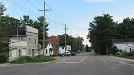
Hartland, Michigan facts for kids
Quick facts for kids
Hartland, Michigan
|
|
|---|---|

Looking south along Hartland Road
|
|
| Country | United States |
| State | Michigan |
| County | Livingston |
| Township | Hartland |
| Area | |
| • Total | 2.28 sq mi (5.92 km2) |
| • Land | 2.28 sq mi (5.91 km2) |
| • Water | 0.00 sq mi (0.00 km2) |
| Elevation | 949 ft (289 m) |
| Population
(2020)
|
|
| • Total | 777 |
| • Density | 340.34/sq mi (131.43/km2) |
| Time zone | UTC-5 (Eastern (EST)) |
| • Summer (DST) | UTC-4 (EDT) |
| ZIP Code |
48353
|
| Area code(s) | 810 |
| FIPS code | 26-37020 |
| GNIS feature ID | 2804670 |
Hartland is a small community in Livingston County, Michigan, United States. It's known as a census-designated place (CDP). This means it's an area that the government counts for population, but it's not officially a city or town with its own local government. Hartland is also an unincorporated community, which means it's part of a larger area called Hartland Township.
A major road, US Highway 23, runs along the western side of Hartland. This highway is important for travel. If you go north on US 23, you can reach Flint in about 27 miles. If you head south the same distance, you'll arrive in Ann Arbor.
Hartland was first officially recognized as a CDP before the 2020 census. This helped gather information about the people living there.
Understanding Hartland's Population
This section helps us learn about the people who live in Hartland. It's like taking a snapshot of the community.
How Many People Live Here?
The government counts how many people live in different places every ten years. This is called a census.
- In 2020, the census showed that 777 people lived in Hartland.
This information helps us understand how communities grow and change over time.
 | Ernest Everett Just |
 | Mary Jackson |
 | Emmett Chappelle |
 | Marie Maynard Daly |


