Hato Nuevo, Guaynabo, Puerto Rico facts for kids
Quick facts for kids
Hato Nuevo
|
|
|---|---|
|
Barrio
|
|

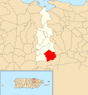
Location of Hato Nuevo within the municipality of Guaynabo shown in red
|
|
| Commonwealth | |
| Municipality | |
| Area | |
| • Total | 3.49 sq mi (9.0 km2) |
| • Land | 3.48 sq mi (9.0 km2) |
| • Water | 0.01 sq mi (0.03 km2) |
| Elevation | 574 ft (175 m) |
| Population
(2010)
|
|
| • Total | 4,114 |
| • Density | 1,182.2/sq mi (456.4/km2) |
| Source: 2010 Census | |
| Time zone | UTC−4 (AST) |
Hato Nuevo is a special area, or barrio, located in the municipality of Guaynabo, Puerto Rico. Think of it like a neighborhood or a district within a bigger town. In 2010, about 4,114 people lived there. It's a part of the beautiful island of Puerto Rico, which is a commonwealth of the United States.
Contents
Understanding the Population of Hato Nuevo
Demographics is about studying people in a certain area. This includes facts like how many people live there and how the population changes over time. The numbers below come from the U.S. Census, which counts everyone living in the country every ten years.
| Historical population | |||
|---|---|---|---|
| Census | Pop. | %± | |
| 1980 | 2,195 | — | |
| 1990 | 3,198 | 45.7% | |
| 2000 | 3,115 | −2.6% | |
| 2010 | 4,114 | 32.1% | |
| U.S. Decennial Census 1899 (shown as 1900) 1910-1930 1930-1950 1980-2000 2010 |
|||
As you can see, the population of Hato Nuevo has grown quite a bit since 1980.
Hurricane Maria's Impact on Hato Nuevo
In 2017, a very strong storm called Hurricane Maria hit Puerto Rico. It was a Category 5 hurricane, which means it was super powerful. Hato Nuevo was affected by this storm. Some areas experienced flooding, and important structures like bridges were damaged.
One bridge in Hato Nuevo collapsed during the hurricane. It took almost a year and a half to replace it. A new bridge was finally finished and opened on February 14, 2019. This was a big step in helping the community recover.
Exploring the Sectors of Hato Nuevo
Barrios like Hato Nuevo are often divided into smaller local areas. These smaller areas are called sectores (pronounced sek-TOR-es). You can think of sectors as smaller neighborhoods or sections within the larger barrio.
The types of sectors can be different. Some are simply called sector, while others might be named urbanización (which means urbanization or housing development), reparto, barriada, or residencial.
Here are some of the sectors you can find in Hato Nuevo barrio:
- Brisas del Caribe
- Calle Paseo de Matilde
- Calle Santa Ana
- Camino Los Navarro
- Camino Sylvia Rodríguez
- Comunidad Alturas de Lomas de Sol
- Sector Capó
- Sector El Coco
- Sector El Faro
- Sector El Laberinto
- Sector Feliciano
- Sector Hato Nuevo II
- Sector Inclán
- Sector Jorge García
- Sector La Pajilla
- Sector La Paloma
- Sector La Vereda
- Sector Limones
- Sector Lomas del Sol
- Sector O’Neill Casañas
- Sector Valle Las Flores
- Urbanización Bel-Air
- Urbanización Colina Mabó
- Urbanización Finca Elena
- Urbanización Greenville
- Urbanización Lomas del Sol
- Urbanización Mountain View
- Urbanización Valle Escondido Estates
- Urbanización Villa Mercedes
See also
 In Spanish: Hato Nuevo (Guaynabo) para niños
- List of communities in Puerto Rico
- List of barrios and sectors of Guaynabo, Puerto Rico


