Haughey's Fort facts for kids
Haughey's Fort is an ancient hilltop fort located in County Armagh, Northern Ireland. It sits about 3.6 kilometers (2.25 miles) west of the city of Armagh. This special place is named after a farmer who owned the land in the late 1800s.
Haughey's Fort is a very important historical site. It is officially recognized as a Scheduled Historic Monument. You can find it in the area called Tray, within the Armagh City and District Council. Its exact location is grid reference H8351 4529.
Discover Haughey's Fort
Haughey's Fort is a type of ancient settlement known as a hill fort. These were often built on hills for protection. People lived inside these forts a very long time ago.
What Does Haughey's Fort Look Like?
This fort is shaped like a large oval. At its widest point, it stretches about 350 meters (1,150 feet across). It has two big ditches, one inside the other, that circle around it. These are called "concentric ditches" because they share the same center.
Inside these outer ditches, there is another, smaller ditch. This inner ditch surrounds an area about 150 meters (490 feet) wide. These ditches and banks would have helped protect the people living inside.
Life in the Bronze Age
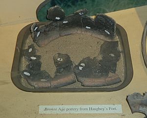
Scientists have studied Haughey's Fort through something called "archaeological excavation." This is like carefully digging up clues from the past. These digs show that people lived here during the late Bronze Age. This was a very long time ago, between 1100 and 900 BC.
After this time, the fort was left empty for a while. However, some objects found there are from the later Iron Age. This suggests that people might have come back to live at Haughey's Fort again later on.
Haughey's Fort was active at the same time as another nearby ancient site called the King's Stables. The King's Stables is an artificial pool, also from the Bronze Age. Haughey's Fort was abandoned before Navan Fort, another famous ancient site about 1 kilometer (0.6 miles) to the east, became a busy place.


