
Haut-Uélé facts for kids
Quick facts for kids
Haut-Uélé
|
||
|---|---|---|
|
Province
|
||
| Province du Haut-Uélé | ||
|
||
_-_Haut-Uele.svg) |
||
| Country | ||
| Established | 2015 | |
| Named for | Uele River | |
| Capital | Isiro | |
| Area | ||
| • Total | 89,683 km2 (34,627 sq mi) | |
| Area rank | 14th | |
| Population
(2005 est.)
|
||
| • Total | 1,920,867 | |
| • Rank | 17th | |
| • Density | 21.41841/km2 (55.4734/sq mi) | |
| Time zone | UTC+2 (Central Africa Time) | |
| License Plate Code | ||
| Official language | French | |
| National language | Lingala | |
| Website | https://twitter.com/DuUele | |

Haut-Uélé (which means "Upper Uélé" in French) is an important province in the Democratic Republic of the Congo. It was created in 2015 as part of a big change to how the country is divided. Haut-Uélé, along with Bas-Uélé, Ituri, and Tshopo provinces, used to be part of a much larger area called Orientale province.
The province is named after the Uele River, which flows through the region. Its capital city is Isiro.
Contents
Understanding Haut-Uélé's Government
Haut-Uélé is led by a Governor, who is like the main leader of the province. The capital city, Isiro, is where the provincial government is located and where important decisions are made.
Main Towns and Communities
Several towns and communities are important in Haut-Uélé. These places are where many people live and work.
- Isiro (the capital city)
- Niangara
- Dungu
- Faradje
- Watsa
- Rungu
- Wamba
How the Province is Divided
For easier management, Haut-Uélé is divided into smaller areas called territories. Each territory has its own local administration.
- Dungu
- Faradje
- Niangara
- Rungu
- Wamba
- Watsa
There is also a village called Bagbele within the province.
Images for kids
-
The official emblem of Haut-Uélé province.
-
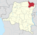
A map showing where Haut-Uélé is located in the Democratic Republic of the Congo.
See also
 In Spanish: Provincia de Alto Uele para niños
