
Hawaiʻi Kai, Hawaii facts for kids


Hawaiʻi Kai is a large neighborhood located in Honolulu, on the island of Oʻahu. It is also known as Maunalua or Koko Marina. Hawaiʻi Kai is mostly a residential area, meaning many people live there. It is the biggest community on the eastern side of Oʻahu.
A famous businessman named Henry J. Kaiser helped develop this area. He built it around an old Hawaiian fishpond and wetlands called Kuapā. Starting in 1959, the Kuapā Pond was dug out, or "dredged." This turned the shallow pond into a marina with channels and islands. Houses and shops were then built on these new areas.
Contents
Where is Hawaiʻi Kai?
Hawaiʻi Kai is on the eastern side of Oʻahu. To its west is the Kuliʻouʻou neighborhood. To the east, you'll find the Koko Head area, which is now part of Koko Head Park.
South of Hawaiʻi Kai is Maunalua Bay, a beautiful ocean area. To the north are the Koʻolau mountains. The main road, Kalanianaʻole Highway, goes through Hawaiʻi Kai and eventually leads to Makapuʻu Point on the windward (eastern) side of the island.
Hawaiʻi Kai is about 12 miles (19 kilometers) east of downtown Honolulu.
The Ancient Hawaiian Fishpond
Maunalua Bay was once famous for having the largest Native Hawaiian fishpond on Oʻahu. This huge fishpond was called Keahupua-O-Maunalua. It covered about 523 acres!
The fishpond had a special wall, or kuapā, that stretched from Kuliʻouʻou to Portlock. People used the pond mainly to raise mullet fish. It was also a home for many native waterbirds. Fishing and farming were very important in this area until the 1950s. Then, the fishpond was filled in to make space for new homes.
Communities in Hawaiʻi Kai
Hawaiʻi Kai has several smaller communities within it.
Kalama Valley
Kalama Valley is one of these communities. It has a shopping center, a public park with basketball courts, and mostly single-family homes. These homes are quite expensive because of the great location in Hawaiʻi Kai.
There are many fun places near Kalama Valley, like the Hawaiʻi Kai Golf Course and Sandy Beach. You can also visit the Makapuʻu Lighthouse, Koko Crater Botanical Garden, and Hanauma Bay, which is famous for snorkeling.
Kamehame Ridge
Kamehame Ridge is a ridge located between Kalama Valley and Kamilo Iki Valley. It was developed in the 1990s. Today, you can find very expensive homes stretching all the way up the ridge. It's also known for a popular hiking trail called “Dead Man’s Catwalk.”
Education in Hawaiʻi Kai
Hawaiʻi Kai is part of the Hawaiʻi Department of Education's Kaiser Complex. It has several schools:
- Henry J. Kaiser High School
- Hahaʻione Elementary School
- Kamiloiki Elementary School
- Koko Head Elementary School
The elementary schools usually send their students to Niu Valley Middle School. After middle school, students typically go to Kaiser High School.
Images for kids
-
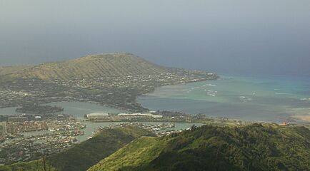
Hawaiʻi Kai and the Hanauma Crater
-
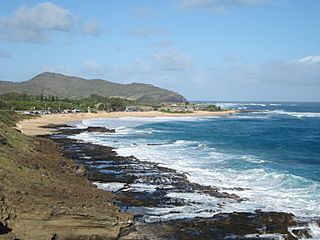
Hawaiʻi Kai's Sandy Beach
-
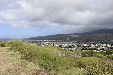
The view of Hawaiʻi Kai from the nearby lookout point.
-
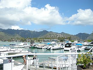
Marina in Hawaiʻi Kai


