
Koʻolau Range facts for kids
Quick facts for kids Koʻolau Range |
|
|---|---|

View of Koʻolau Range from offshore Lanikai (windward coast)
|
|
| Highest point | |
| Peak | Kōnāhuanui |
| Elevation | 3,150 ft (960 m) |
| Prominence | 2,303 ft (702 m) |
| Geography | |

Koʻolau Range
Location in Hawaii
|
|
| Location | Oahu, Hawaii, US |
| Parent range | Hawaiian Islands |
| Topo map | USGS Kilohana (HI) |
| Geology | |
| Age of rock | 1.7 Ma |
| Mountain type | Dormant shield volcano |
| Volcanic arc/belt | Hawaiian-Emperor seamount chain |
| Last eruption | 32,000 - 10,000 BP |
| Climbing | |
| Easiest route | trail |
| Designated: | 1972 |
The Koʻolau Range is a long mountain ridge on the island of Oahu in Hawaii. It is actually what's left of a very old, sleeping shield volcano. This volcano used to be much bigger! The Koʻolau Range was named a National Natural Landmark in 1972 because of its special natural features.
Contents
How the Koʻolau Range Formed
The Koʻolau Range is not a typical mountain range that formed from Earth's plates crashing together. Instead, it was once a single giant volcano called Koʻolau Volcano. The word koʻolau means "windward" in the Hawaiian language, referring to the side of the island that faces the wind.
A very long time ago, a huge part of this volcano, including its top caldera (a large crater), broke off. It then slid into the Pacific Ocean in a massive landslide! What we see today as the Koʻolau Range is the western half of that original volcano. Pieces of the old volcano are spread out for about 100 km (60 mi) across the ocean floor.
Kāneʻohe Bay on Oahu's windward side is actually what remains of the volcano's old summit caldera after this huge slide. The Koʻolau mountains now form Oahu's windy coast. They also rise up behind the city of Honolulu on the island's calmer, leeward side. Most of Honolulu's neighborhoods are built on the slopes and valleys of these mountains.
Scientists believe the Koʻolau Volcano first started erupting on the ocean floor more than 2.5 million years ago. It grew taller and taller until it reached sea level. It kept growing until about 1.7 million years ago, when it became dormant, meaning it stopped erupting.
For hundreds of thousands of years, the volcano stayed quiet. During this time, erosion (like wind and rain) slowly wore away its smooth slopes. The whole mountain also sank quite a bit. The highest point of the volcano might have once been over 3,000 m (9,800 ft) tall. Today, the tallest peak, Puʻu Kōnāhuanui, is only about 945 m (3,100 ft) high.
Later Eruptions: Honolulu Volcanics
After a very long sleep, the Koʻolau Volcano became active again. Over the past 500,000 years, about thirty eruptions have happened. These eruptions created many famous landmarks around eastern Oahu.
Some of these well-known spots include Diamond Head, Koko Head (where Hanauma Bay is), Koko Crater, Punchbowl Crater, Tantalus, and Āliapaʻakai. These later eruptions are known as the Honolulu Volcanics.
The US Geological Survey says that the most recent eruptions in this series happened between 70,000 and 100,000 years ago. While it's possible the Koʻolau Volcano could erupt again, the chances are very, very small. It's not likely to happen in our lifetimes or even for many generations to come.
Getting Through the Koʻolau Range
There are three main roads that go through tunnels in the southern part of the Koʻolau Range. These tunnels connect the city of Honolulu on the leeward side to the windy Windward Coast.
The roads are:
- Hawaii Route 61 (Pali Highway)
- Hawaii Route 63 (Likelike Highway)
- Interstate H-3
Images for kids
-
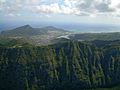
View of Koʻolau Range with Koko Crater and Maunalua (Hawaii Kai) visible.
-
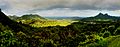
Nuʻuanu Pali, a section of the Koʻolau Range.
-
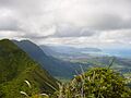
View of Koʻolau Range from the top. Kāneʻohe is visible on the right side.


