
Honolulu Volcanics facts for kids
Quick facts for kids Honolulu Volcanics |
|
|---|---|
.JPG)
Topography of southeastern Oʻahu
|
|
| Highest point | |
| Geography | |

Honolulu Volcanics
Location in Hawaii
|
The Honolulu Volcanics are a group of volcanoes that make up a volcanic field on the island of Oʻahu, Hawaiʻi. You can find them in the southeastern part of the island, especially around the city of Honolulu, stretching from Pearl Harbor to the Mokapu Peninsula. These volcanoes are part of a later stage of Hawaiian volcanic activity, which happened after the main volcano that built the Koʻolau on Oʻahu.
These volcanoes formed mostly through explosive eruptions. They created different types of volcanic features like cinder cones (cone-shaped hills of volcanic rock), lava flows, tuff cones (cones made of hardened volcanic ash), and even small volcanic islands. Some very famous landmarks like Diamond Head and Punchbowl Crater are part of the Honolulu Volcanics.
Volcanic activity started less than a million years ago. It happened at about 30 to 40 different spots, some of which are underwater. The sea level changed a lot while these volcanoes were active, and some eruptions have been dated by matching them to these sea level changes. The volcanoes erupted different kinds of lava, mostly basalt (a common type of volcanic rock), often with many xenoliths (pieces of other rocks brought up by the magma). When magma rose during eruptions, it often mixed with water, causing powerful steam explosions. This created special volcanic structures like tuff cones. The last eruption happened about 35,000 or 76,000 years ago. It's possible for future eruptions to happen, but it's very rare.
Contents
Where are the Honolulu Volcanics?
The Honolulu Volcanics are a series of volcanoes located in the southeastern part of Oʻahu. They include different volcanic features like dikes (sheets of rock that cut through older rock), lava flows, spatter cones (small, steep-sided cones), tephra (volcanic ash and rock fragments), tuff cones, and mesas (flat-topped hills). These volcanic spots are found southeast of a line connecting Mokapu Peninsula and Pearl Harbor. They stretch from the ridges of the older Koʻolau volcano down to the coast and even below sea level.
The volcanic system is named after Honolulu, the capital of Hawaiʻi, because many of its craters are scattered in and around the city. Famous landmarks like Diamond Head, Koko Head, Punchbowl Crater, Rabbit Island, Tantalus, Hanauma Bay (a popular snorkeling spot), and the Mokapu Peninsula (where Marine Corps Base Hawaiʻi is located) are all part of this volcanic system. The United States military has even used some of the islands formed by these volcanoes. The Koko area is now the Koko Head Regional Park, and Hanauma Bay is a state park. These areas are some of the most well-known volcanic spots in Hawaiʻi.
About 30 to 40 different volcanic vents have been found. Most of the cinder cones on Oʻahu are quite large, often over 250 feet (76 meters) high and up to 0.5 miles (0.8 kilometers) wide. Some of the lava flows filled deep valleys that were carved into the older Koʻolau volcano. This changed the path of streams that used to flow through these valleys. For example, water flowing over a lava flow in Kamanaiki Valley now forms a waterfall. The deposits from the Honolulu Volcanics, along with sediments from the mountains and coral reef growth, have created the flat coastal plain where Honolulu and military bases are built today.
The vents of the Honolulu Volcanics tend to line up in a northeast direction. This direction is at a right angle to the rift zone (a crack in the Earth's crust where magma rises) of the Koʻolau volcano. It's not fully clear if these alignments are connected to the older Koʻolau volcano or if they are controlled by the crust of the Pacific Ocean.
There are also underwater vents. One is a 300-meter-high cone with two ridges off northeast Oʻahu, covered by pillow lavas (lava that forms rounded shapes underwater) and volcanic sediments. Other cones are found off the southwest extension of the Koko Rift. Another group of underwater vents is located south of Diamond Head.
-
Hanauma Bay in the foreground, Koko is in the middle
-

Diamond Head to the left, Punchbowl in the middle
.jpg)
Famous Volcanoes of Honolulu
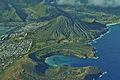
Much of the current shoreline of Hawaiʻi Kai was created by the Honolulu Volcanics. Kuapā Pond is a lake left behind between the new shoreline and the older shoreline of the Koʻolau volcano. The volcanic spots there include Koko Head, the Hanauma Bay craters, Kahauloa crater bay, and Koko Crater. The Koko Head cones are very worn down by erosion, and the sea has broken into one of them, showing its inside structure. Koko Head is the largest cone of the Honolulu Volcanics, and Koko Crater's opening is about 1 kilometer (0.6 miles) wide.
Hanauma Bay is about 13 kilometers (8 miles) east of Honolulu. It's a large, shallow crater that was formed by a tuff cone. The sea broke into it, and now coral reefs grow inside. Hanauma Bay, Kahauloa, and Kalama are all part of the Koko Rift.
Diamond Head is a well-known tuff cone about 1,700 meters (1.1 miles) wide from rim to rim. It has a wide, not-too-deep crater and stands out as a prominent point east of Honolulu. Inland from Diamond Head are the Kaimukī and Mauʻumae cones, which seem to have come from the same crack in the Earth. Kaimukī is an unusual lava cone with a crater at its top. Its sides are gentle, and lava flowed and piled up against hills. These cones, along with Kaʻau crater, form the Kaʻau or Kaimukī rift zone. Kaʻau crater is near the top of the Koʻolau Range and is filled with a swamp.
Punchbowl Crater rises north of and in the center of Honolulu. It offers a great view of the city and its surroundings.
The Mokapu peninsula was formed by the Honolulu Volcanics. It includes three volcanic vents: Puʻu Hawaiʻiloa, Pyramid Rock, and Ulapaʻu Head. Other vents form small islands off the peninsula, like Moku Manu and Mōkōlea Rock. Puʻu Hawaiʻiloa is a cinder cone in the middle of the peninsula. Pyramid Rock, at the northwestern tip, is very eroded and likely the oldest vent there. Ulapaʻu Head is a crater that was broken open by the sea, and only a crescent-shaped western part remains.
Salt Lake Crater has a salt lake inside it and is located east of Pearl Harbor. The salt lake formed when salty groundwater seeped into the crater and became more concentrated through evaporation. Several older vents like ʻĀliamanu and Makalapa are connected to Salt Lake Crater. The Salt Lake Tuff (hardened volcanic ash) covers an area of at least 5 square miles (13 square kilometers). Honolulu International Airport and Hickham Air Force Base are south and southwest of these vents. Some of these vents are known as maars, which are wide, low-relief craters formed by explosive eruptions.
How the Volcanoes Formed
The Honolulu Volcanics grew on top of the much older Koʻolau Volcanic Series, which is about 2.3 million years old. The Koʻolau volcano forms the main part of eastern Oahu and extends far underwater. Like other Hawaiian volcanoes, Koʻolau is a shield volcano, which means it's wide and gently sloped, built up by many lava flows. It had a central caldera (a large basin-shaped depression).
The Honolulu Volcanics are a later stage of volcanism in Hawaiʻi, known as the "rejuvenated stage." They are much smaller in total volume than the Koʻolau volcano, even though their lava flows are usually thicker. Scientists recognized long ago that the Honolulu Volcanics formed on top of the older Koʻolau rocks.
As Hawaiian volcanoes grow, they start to sink under their own weight. The "Hawaiian Arch" is a bulge in the Earth's crust that moves behind the active volcanoes. When this arch passed under Oahu, it might have caused the Honolulu Volcanics to start erupting. Other ideas include heating of the Earth's outer layer or continued rising of hot rock from deep within the mantle plume (a column of hot rock rising from the Earth's mantle).
These volcanoes grew on different types of ground, including old volcanic rocks from Koʻolau, coastal plain sediments, and soils. Some Honolulu Volcanics grew on coral deposits, like Koko Head, which formed on limestone. Coral reefs were common when the Honolulu Volcanics were active.
What are the Rocks Made Of?
The rocks from the Honolulu Volcanics have been studied a lot. They are quite varied, including different types of basalt and other related rocks. These differences show that the rocks came from different mixtures of melted material deep underground. They contain crystals of minerals like olivine and plagioclase. They also often contain xenoliths, which are pieces of other rocks from deep within the Earth's mantle that were carried up by the magma.
Scientists have found coral fragments in rocks from Koko and Salt Lake. Also, metamorphic rocks (rocks changed by heat and pressure) found in the volcanoes might be part of the deeper rock layers that the magma traveled through. The calcite crystals, which give Diamond Head its name, might come from coral reefs, groundwater, or even the magma itself. Studies suggest that groundwater carbonates (minerals containing carbon and oxygen) are the most likely source.
Rocks from Punchbowl Crater, which have been quarried, are usually brown to yellow. Cinders are typically red-black but can turn yellow if they are changed by hot water, forming a glassy rock called palagonite. Many of the erupted rocks have been changed to different degrees, forming minerals like zeolitic palagonite. In some volcanoes, like Diamond Head, the rocks are so changed that their original makeup can't be figured out.
Where Did the Magma Come From?
The rocks of the Honolulu Volcanics came from deeper parts of the Earth than the rocks from the Koʻolau volcano. Their chemical makeup is also quite different. Scientists have suggested that the magma might have come from a type of rock called pyroxenite. Water and carbon dioxide gases might have changed the source rocks before they melted. The ultimate origin of the magma is still debated, but it likely involves a mix of different types of rock from the Earth's mantle.
Water in the Rocks
Water found in the rocks of the Honolulu Volcanics, though not a huge amount, is important in some areas. However, most of the groundwater on Oʻahu is found in the older Koʻolau volcanic rocks. Some groundwater in Honolulu Volcanics rocks is salty. This salty water has been used for things like a sea-life park at Makapuʻu.
History of Eruptions
When Did They Erupt?
The Honolulu Volcanics started erupting less than a million years ago, after the Koʻolau volcano had stopped being active and had been worn down a lot. The first eruptions happened inside the Koʻolau caldera (the large basin at the top of the old volcano). The youngest eruptions were in the far southeastern part of Oʻahu, in the Koko Rift area.
Scientists have linked the eruptions of the Honolulu Volcanics to changes in sea level. These changes left behind platforms and terraces on Oʻahu that are now either underwater or above sea level. Some volcanoes formed when the sea level was lower than today, so parts of them are now submerged. Others formed when the sea level was higher and grew on reefs. These sea level changes are connected to ice ages and warmer periods, where higher sea levels happened when polar glaciers melted.
Early dating methods gave ages ranging from 800,000 to 60,000 years old. However, some dating methods can be unreliable for these rocks because of extra gases trapped inside. More accurate dating methods have shown ages between 700,000 and 400,000 years for underwater vents northeast of Oʻahu, and around 140,000 years for southwest underwater vents.
Volcanic activity happened in two main periods: one between 800,000 and 250,000 years ago, and another in the last 120,000 years, with a quiet period in between. Eruptions in the Koko Rift happened between 100,000 and 60,000 years ago. It's not clear which rift erupted last, as ages of 35,000 and 85,000 years have been found for the Koko Rift, while the Tantalus Rift has ages around 76,000 years ago. On average, an eruption in the Honolulu Volcanics might happen every 35,000 years, if the younger dates for the Koko Rift are correct.
How Did They Erupt?
Many eruptions were very explosive. This was probably because the magma had a lot of gases in it. These eruptions threw tephra (volcanic ash and rock fragments) high into the air. When the rising magma hit water, especially near the coast, powerful steam explosions happened. These explosions threw up rock debris, including older rocks like coral fragments.
Lava flows usually came out during the later part of an eruption and were typically small. The longest flow is 7 kilometers (4.3 miles) long, and the largest one at Kaimukī forms a lava shield or lava dome about 4 square kilometers (1.5 square miles) in size. Cinder cones form from volcanic material falling out of the air, like cinders, lava bombs, and pumice. Tuff cones can also contain non-magmatic rock pieces. Many of these eruptions, like the one that formed Diamond Head, probably only lasted a short time, maybe just a few hours, similar to what has been seen in recent eruptions elsewhere.
The area also experienced many Surtseyan or phreatomagmatic eruptions. These happen when rising magma meets water, like at Mānana Island, Koko, and Punchbowl. These eruptions were very explosive and are some of the best examples of Surtseyan activity in the United States. Some formed small islands when they broke through the water.
Volcanic rocks from Honolulu Volcanics include agglomerates (rock fragments cemented together), breccia (broken rock fragments), and tuffs (hardened volcanic ash). Tephra can be in the form of lapilli (small rock fragments) and volcanic ash. Some eruptions were followed by lahars (volcanic mudflows) when volcanic ash was washed away by streams. During eruptions, trade winds blew material from the vent. This wind-driven movement is why many volcanoes, like Diamond Head, have an uneven shape, with one side higher than the other.
Drill cores (samples taken by drilling into the ground) in Hanauma Bay have found layers of ash. A black ash known as "black sand" is common across Honolulu. It came from volcanic eruptions of the Honolulu Volcanics. Ash layers cover coral reef deposits both on land and offshore, as far as ʻEwa Beach. Ash from the Salt Lake Craters was carried by winds to Pearl Harbor and is thought to have helped form the bay by blocking its access to the sea.
Here's what happened at some specific volcanoes:
- At Diamond Head, eruptions started underwater. They first deposited white rocks made mostly of old coral. Then, proper tuff layers were laid on top.
- The formation of Kaʻau Crater also involved phreatic activity (explosions caused by steam) that deposited volcanic ash. Some eruptions, like those of Kaʻau, Mōkōlea, and Training School, might have happened as one long event along a 13-kilometer (8-mile) line.
- Very explosive eruptions happened when magma erupted underwater, forming Hanauma Bay. The eruption happened in several stages, with short breaks of only a few months. Erosion was already happening during the eruption. After Hanauma Bay formed, coral reefs grew inside it.
- Koko Head was formed by the Koko Tuff. Later, other explosion craters, like Hanauma Bay, formed within Koko Head. Koko Crater also produced an ash layer that covers the surrounding area.
- Punchbowl Crater formed from volcanic material falling out of an eruption column (a column of ash and gas rising from a volcano). This material fell onto the coral plain where the vent was, creating the crater.
- The Sugarloaf lava flow was accompanied by falling tephra. This tephra was over 1 meter (3.3 feet) thick 6 kilometers (3.7 miles) away in what is now downtown Honolulu. The lava flow itself is 15 meters (49 feet) thick and is a type called ʻaʻā (a rough, jagged lava flow). The eruption of the Tantalus vent seemed to happen at the same time as Sugarloaf. Both eruptions were very explosive because the magma had a lot of gases.
- Ulupaʻu Head crater once held a lake, which was the largest lake in Hawaiʻi. It lasted for a long time until the sea broke through the crater rim. Many bird fossils have been found in the lake's deposits.
Many of the Honolulu Volcanics have grooves or furrows on their sides. erosion has cut gullies into the slopes of Diamond Head and Punchbowl Crater. Wavecut terraces formed on some volcanoes during periods of high sea level. It's likely that wave erosion broke into Hanauma Bay, flooding it, either during or after the eruption that created it.

Future Activity and Dangers
The most recent eruptions in this volcanic field happened either 30,000 or 76,000 years ago. There are no stories or records from Hawaiian tradition about eruptions happening in historical times. While some thought the youngest eruptions were only 5,000 to 10,000 years old, more accurate radiometric dating has not found any eruptions younger than 31,000–43,000 years old.
Future eruptions of the Honolulu Volcanics are possible, but the chance of a new eruption in the next hundred or thousand years is considered very, very small. It's probably similar to the lowest risk area of Hawaiʻi Island. Also, if an eruption were to happen, it would likely only affect small areas of Oʻahu.
Any future eruption would probably occur in the southeastern part of Oʻahu and would be small. It would likely involve falling cinders, lava flows, and mudflows, similar to past Honolulu Volcanics eruptions:
- Tephra fall: Volcanic ash and rock fragments would be carried by winds, most likely to the southwest. Depending on where the eruption happens, this could fall over downtown Honolulu and Pearl Harbor. Dangers of tephra fall include roofs collapsing, air and water pollution, poor visibility, and damage to machines and plants. Closer to the vent, volcanic gases and falling lava bombs would be additional dangers. Tephra deposits can be washed away by rainfall, forming mudflows that can be very fast and dangerous.
- Steam explosions: These could create powerful lateral blasts (explosions spreading sideways). These blasts can travel at high speed up to 8 kilometers (5 miles) from the vent, carrying dangerous heat and debris. Such blasts might have happened when Diamond Head, Koko Head, and Punchbowl formed.
- Lava flows: Lava flows can cause serious damage to property by destroying anything in their path. However, because they move slowly, they are rarely a threat to people's lives. Also, a lava flow would most likely be preceded by other volcanic events, which would give people time to leave the danger zone before the lava becomes a threat.
List of Volcanoes
| Name | Age in years before present | Photo | What it's like (most have a cone and lava flows) | Location |
|---|---|---|---|---|
| ʻAinoni | 440,000 ± 30,000 | 2 miles (3.2 km) southwest of Olomana Peak | ||
| ʻĀkulikuli | 290,000 ± 70,000 | |||
| ʻĀliamanu | 250,000 ± 40,000 | Maar (a wide, flat crater) | Between Pearl Harbor and Honolulu, northwest of Salt Lake Crater | |
| Black Point | 400,000 - 330,000 | Cone and lava flow just south of Diamond Head. | Southeast of Diamond Head | |
| Castle | 410,000 ± 50,000 | Lava flow at the foot of the Nuanuʻu cliffs. | 3 miles (4.8 km) east of Kailua | |
| Diamond Head | 520,000 - 350,000 or 360,000 ± 70,000 | Southeast of Honolulu | ||
| Haʻikū | 800,000 ± 80,000 | Found on the crest of the Koʻolau Range. A lava flow is found at Heʻeia Stream at 50 feet (15 meters) elevation. | At the head of the valley of the same name | |
| Hanauma Bay | 70,000 ± 30,000 | Tuff cone | East of Honolulu close to Koko Head peninsula | |
| Kaʻau | 580,000 ± 120,000 | At the head of the Pālolo valley | ||
| Kahauloa | 70,000 ± 30,000 | Tuff cone | East of Honolulu just southwest from Koko Head. | |
| Kaimukī | 380,000 ± 110,000 | Lava cone or lava dome | In Kaimukī, Honolulu on the northern side of Diamond Head | |
| Kalama | 80,000 - 60,000 | Lava flow with a cinder cone | Northeast of Koko Head | |
| Kalihi | 460,000 ± 70,000 | Volcanic rocks on the crest of the Koʻolau Range, including cinder cones and lava flows. A lava flow is found in Honolulu at 40 feet (12 meters). | At the head of the valley of the same name | |
| Kamanaiki | 590,000 ± 20,000 | Lava flows | In the Kamanaiki valley | |
| Kāneʻohe | 500,000 ± 90,000 | 2 miles (3.2 km) south of the place of the same name | ||
| Kāohikaipu | Cone that forms an island | Northeast of Makapuʻu Point, the easternmost tip of Oʻahu | ||
| Kaupō | 100,000 ± 60,000 | Spatter cone and lava flow | ||
| Koko Crater | 100,000 ± 30,000 | Tuff cone | East of Honolulu | |
| Luakaha | 470,000 ± 30,000 | Together with Makuku forms the Nuanuʻu group | At the head of the Nuanuʻu valley | |
| Makalapa | 470,000 ± 60,000 | Maar or crater just east from Pearl Harbor, which drops off steeply from about 100 feet (30 meters) to the shore. | Northwest from Honolulu and directly east from Pearl Harbor (at grounds of United States Pacific Fleet headquarters) | |
| Makawao | Olomana Peak lies 2 miles (3.2 km) northeast | |||
| Makuku | 400,000 ± 30,000 | Together with Luakaha forms the Nuanuʻu group | At the head of the Nuanuʻu valley | |
| Mānana | Tuff cone, also known as Rabbit Island, in Waimānalo Bay. | Northwest of Makapuʻu Point, the easternmost tip of Oʻahu. It appears to be formed by two cones, with one crater still preserved. | ||
| Mānoa | 200,000 - 70,000 | |||
| Maunawili | 790,000 - 780,000 | Cinder cone and lava flow | South of Olomana Peak | |
| Mauʻumae | 480,000 ± 40,000 | In Kaimukī, Honolulu | ||
| Mōʻiliʻili | 90,000 ± 90,000 and more recently 76,000 | |||
| Mōkōlea | 580,000 ± 90,000 | Also known as Mokapu South or Mokulea | In Kailua Bay | |
| Moku Manu | 700,000 ± 80,000 | An island. | North of Mokapu Point | |
| Pali | 640,000 - 600,000 | At the Pali road close to the crest of the Koʻolau Range | ||
| Pali Kilo | 400,000 ± 40,000 | On Mokapu peninsula | ||
| Punchbowl Crater | 430,000 - 390,000 | At the centre of Honolulu | ||
| Puʻu Hawaiʻiloa | 450,000 - 420,000 | Located on Mokapu peninsula, it is a symmetric cinder cone with associated lava flows. | On Mokapu peninsula | |
| Pyramid Rock | 680,000 ± 100,000 | Located on Mokapu Peninsula, close to Puʻu Hawaiʻiloa. | On Mokapu peninsula | |
| Rocky Hill | 60,000 - 40,000 or 60,000 ± 70,000 | Located close to Punahou School, the vent consists of one main cinder cone and smaller vents and lava flows. | At Punahou Street | |
| Round Top | Cone | On the divide between Pauoa and Mānoa valleys | ||
| Salt Lake | 430,000 | Tuff Cone | Northwest from Honolulu | |
| Sugar Loaf | 76,000 ± 1,000 | Tuff Cone, cinder cone with ash and lava. The vents that created the flow are also known as Round Top and Puʻu Kakea | On the divide between Pauoa and Mānoa valleys | |
| Tantalus | 110,000 - 80,000 | Tuff Cone | On the divide between Pauoa and Mānoa valleys | |
| Training School | 580,000 ± 100,000 | Lava flow accompanied by a mudflow | North of Olomana Peak | |
| Ulupaʻu Head | 600,000 - 400,000 | Ulupaʻu cone is located on Mokapu peninsula, and forms its tip and its highest point. | The tip of Mokapu peninsula |


.jpg)


