
Interstate H-3 facts for kids
Quick facts for kids
|
|
|---|---|
| John A. Burns Freeway | |
| Lua error in Module:Infobox_road/map at line 15: attempt to index field 'wikibase' (a nil value). | |
| Route information | |
| Maintained by HDOT | |
| Length | 15.32 mi (24.66 km) |
| Existed | 1972:(Kamehameha Highway-Kaneohe MCBH) 1997: (Kamehameha Highway-Halawa)–present |
| Major junctions | |
| West end | |
| East end | Marine Corps Base Hawaii |
| Highway system | |
| Main route of the Interstate Highway System Main • Auxiliary • Business Routes in Hawaii |
|

Interstate H-3 is a major highway in the American state of Hawaii. It's often called the John A. Burns Freeway. This road helps people travel across the island of Oahu. It connects the western side, near Halawa, to the eastern side, ending at Marine Corps Base Hawaii. The entire route is about 15.32 miles (24.66 kilometers) long.
Contents
Exploring Interstate H-3
Interstate H-3 is a special highway because of how it was built. It goes through mountains and valleys, offering amazing views. It's a key route for people living on Oahu.
Starting Your Journey
The highway begins in Hālawa, on the western side of Oahu. Here, it connects with two other important highways: Interstate H-1 and Interstate H-201. This area is known as the Halawa Interchange.
Traveling Through Valleys
After starting, Interstate H-3 travels along a special bridge called a viaduct. This viaduct stretches for about 6 miles through Halawa Valley. A viaduct is like a very long bridge that carries the road over low areas or other roads.
Next, the highway goes into the Tetsuo Harano Tunnels. These tunnels cut right through the Koʻolau Mountains. These mountains are a famous landmark on Oahu.
Reaching the East Side
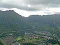
Once you exit the tunnels on the eastern side, the highway continues on another viaduct. This one is built along the side of Haiku Valley. It's a very scenic part of the drive.
The highway then reaches the Kaneohe Interchange. Here, it connects with state route 63 (Likelike Highway), which leads into the town of Kaneohe.
A bit farther, you'll find the Halekou Interchange, where it meets state route 83 (Kamehameha Highway). About four miles past this point, Interstate H-3 reaches the main entrance of Marine Corps Base Hawaii.
Cool Sights Along H-3
-
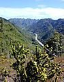
Interstate H-3 in Halawa Valley looking towards the Ko'olau mountains
-

The long viaducts of H-3 within Halawa Valley
-
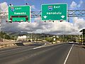
Interstate H-3 eastbound at the exit for H-201 east
-
An aerial view of the tunnel's eastern entrance


_at_the_exit_for_Interstate_H-201_EAST_(Honolulu)_in_Halawa,_Oahu,_Hawaii.jpg)

See also
 In Spanish: Interestatal H-3 para niños
