Halawa, Hawaii facts for kids
Quick facts for kids
Halawa
|
|
|---|---|

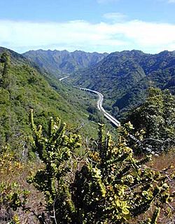
Interstate H-3 in Halawa Valley looking towards the Koʻolau crest
|
|

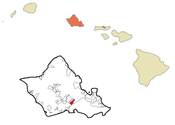
Location in Honolulu County and the state of Hawaii
|
|
| Country | |
| State | |
| County | Honolulu |
| Area | |
| • Total | 2.39 sq mi (6.19 km2) |
| • Land | 2.39 sq mi (6.19 km2) |
| • Water | 0.00 sq mi (0.00 km2) |
| Elevation | 177 ft (54 m) |
| Population
(2020)
|
|
| • Total | 15,016 |
| • Density | 6,285.48/sq mi (2,427.05/km2) |
| Time zone | UTC-10 (Hawaii-Aleutian) |
| Area code(s) | 808 |
| FIPS code | 15-10000 |
| GNIS feature ID | 1867251 |
Halawa (Hawaiian pronunciation: [həˈlɐvə]) is a special area in Honolulu County, Hawaii, United States. It's called a census-designated place (CDP). This means it's a place with people living there that the government counts for information, but it's not officially a city or town.
Halawa is known for its two valleys, North and South Halawa, which are formed by streams. Most of the Halawa Valley is still natural and undeveloped. In 2020, about 15,016 people lived here.
You can find the main office for the United States Indo-Pacific Command at Camp H. M. Smith in Halawa. Also, the Hālawa (Aloha Stadium) Skyline station is located at the bottom of the valley.
Contents
Cultural History of Halawa
The entire area of Halawa is very important to the Kanaka Maoli, who are the Native Hawaiian people.
The Shark Goddess and Pearl Harbor
Near the ocean, at a place called Puʻuloa or Pearl Harbor, Native Hawaiians believe it is the home of a shark goddess named Kaʻahupahau. She is known as the "Queen of Sharks." She was believed to protect the island of Oʻahu and made sure that both sharks and humans behaved kindly and fairly.
Long ago, the area where Kaʻahupahau lived was famous for its many pearl oysters. However, Native Hawaiian religious experts say that the goddess removed all the oysters, and perhaps even herself, because people were not treating the area well. Today, the water in Pearl Harbor has been affected by pollution from different sources. Because of this, it has been marked as a place that needs a lot of cleaning up.
Sacred Upland Areas
The higher, inland part of Halawa is sacred to Papahānaumoku. She is the Native Hawaiian form of Mother Earth. Legends say that this is where she was born and where she mainly lives.
The valley also has some very special women's temples called Hale o Papa, where Papa is honored. There are many other religious and cultural sites in the valley that are important to Native Hawaiians.
Impact of the H-3 Freeway
Over the years, some of these sites were damaged, especially when the H-3 Freeway was built. This freeway was very expensive to build. Even though some sites were lost, many still remain. Native Hawaiian people, called Aloha ʻAina practitioners, still care for these sites today.
In the last 20 years, North Halawa has been a place of strong disagreement. People have been fighting to protect the religious sites and natural resources that were harmed by the H-3 freeway. Some animal species have not been seen since the freeway construction began. The main water source for the area was also damaged, and religious sites were greatly affected.
The freeway opened in 1997, but many people are still working to fix the problems it caused. Some even want the freeway to be closed. In 1993, some Native Hawaiian elders and cultural leaders were arrested while holding a ceremony to pray for the valley. Their religious altar was destroyed, and they were not allowed to visit the sites. Today, some of these elders have returned to care for the sites. They do this even with the noise of the freeway constantly in the background.
Many Native Hawaiians choose not to use the freeway because of these impacts. They also believe the road is haunted. This is one explanation for the many accidents on the freeway, though most people think the accidents happen because drivers often go too fast.
Historical Records
Old records show that the upper part of Halawa was very important to Native Hawaiians. Much of this history is passed down through spoken stories. The Hale O Papa temples were connected to large Ku temples (luakini). These were important temples, usually found in areas with more people and government support.
Over time, the area has changed a lot due to sugarcane plantations, homes, and light industries. For example, a food warehouse now stands where an ancient temple called Waipao Heiau once was.
Neighborhoods of Halawa

The neighborhoods in Halawa are quite spread out. This is partly because of the large highway connections that take up much of the lower Halawa Valley. A lot of the valley along both sides of Interstate H-3 has commercial buildings and light industrial businesses.
On the east side of H-3, you'll find the State Animal Quarantine Station. There is also the Halawa High and Medium Security Facility, which is the main prison for O‘ahu.
Closer to Pearl Harbor, where the valley gets wider, you'll find homes. These include Foster Village, next to Āliamanu. There is also the stadium area, located between Aloha Stadium and Makalapa. The higher land on the west side is called Halawa Heights. This area goes up to Camp H. M. Smith. At its lower, western edge, Halawa Heights connects with the neighborhoods of ‘Aiea.
The postal code for Halawa Heights is 96701, which is the same as for Aiea. The postal code for Foster Village, the stadium area, and Makalapa is 96818, which is the same as Āliamanu.
Geography of Halawa
Halawa is located at 21°22′39″N 157°55′22″W / 21.37750°N 157.92278°W.
The United States Census Bureau says that Halawa covers about 2.3 square miles (6.19 square kilometers) of land. There is no water area within the CDP.
The H-3 freeway starts in Halawa. It connects with the east-west Moanalua Freeway (H-201). The H-201 goes east to Honolulu or west to H-1 and Aiea. The H-3 freeway then goes up to the entrance of the Tetsuo Harano Tunnels, which go through the Ko‘olau mountains. The freeway continues beyond to Kaneohe on the other side of Oahu.
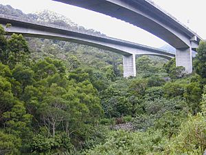
A large part of the H-3 freeway in the valley is built on tall bridges called the Windward Viaducts. These bridges were very expensive to build. However, they were the best way to build such a large freeway through the narrow valley without causing floods or making the ground unstable. They also help protect old historical sites and the stream's natural environment.
Population and People
| Historical population | |||
|---|---|---|---|
| Census | Pop. | %± | |
| 1990 | 13,408 | — | |
| 2000 | 13,891 | 3.6% | |
| 2010 | 14,014 | 0.9% | |
| 2020 | 15,016 | 7.1% | |
| source: | |||
In 2020, the population of Halawa was 15,016 people. This means there are about 6,285 people living in each square mile.
In 2000, there were 13,891 people living in Halawa. About 23.4% of the people were under 18 years old. The average age of people in Halawa was 37 years. For every 100 females, there were about 98.8 males.
Fun Things to Do
Aloha Stadium is located in Halawa. It's a great place for sports and other events.
Schools in Halawa
The Hawaii Department of Education runs the public schools in the area. Aiea Elementary School, Gus Webling Elementary School, and Aiea Intermediate School are all located within the Halawa CDP.
See also
 In Spanish: Halawa para niños
 | Lonnie Johnson |
 | Granville Woods |
 | Lewis Howard Latimer |
 | James West |


