
Maunalua Bay facts for kids


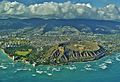
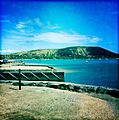
Maunalua Bay is a beautiful bay located in the southeast part of Honolulu, the capital city of Hawaiʻi. This bay stretches for about 6.3 miles (8.5 kilometers). It goes from the southern tip of Diamond Head (also called Black Point or Kūpikipikiʻō) in the west, all the way to Portlock Point (also known as Kawaihoa Point) in the east.
Along the coast of Maunalua Bay, you'll find several neighborhoods. To the east of Diamond Head is the area of Kāhala. Further east, you'll see hillside communities like Hawaii Loa Ridge. The eastern part of the bay is home to Hawaii Kai. This area was developed after World War II by a businessman named Henry J. Kaiser. Hawaii Kai has a marina, places to shop, and many restaurants. The neighborhood of Portlock, which is part of Hawaii Kai, sits on the land leading to Koko Head.
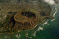
The name Maunalua comes from the native Hawaiian language. Mauna means "mountain" and ʻelua means "two." This name refers to the area around Hawaii Kai during the time of early Polynesian settlement. The two mountains near Portlock Point are Koko Head, which is 645 feet (196 meters) tall, and about 2.2 miles (3.5 kilometers) east, near Hanauma Bay, is Koko Crater, which rises to 1,207 feet (368 meters).
Historians believe Maunalua was one of the first places where people from Polynesia settled in Hawaiʻi, around the 12th century. The native Hawaiians living here were skilled at fishing. They also grew sweet potatoes (ʻuala) along the coast in a place called Ke-kula-O Kamauwai. Maunalua was once famous for having the largest Native Hawaiian fishpond on Oʻahu. This huge fishpond, called Keahupua-O-Maunalua, was 523 acres in size! It had a long wall, or kuapā, that stretched from Kuliʻouʻou headland to what is now Portlock. The pond was mainly used to raise mullet (ʻawaʻawa). Many native waterbirds also lived there. Fishing and farming continued to be important in this area until the 1950s. At that time, the fishpond was filled in to make space for new houses.
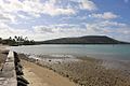
Maunalua Bay Beach Park
This beach park was created by Henry J. Kaiser when he was developing the Hawaii Kai Marina. To build it, about 535,000 square feet (49,703 sq. m) of coral was dug up and moved. This created a channel for boats. Kaiser then gave the park to the City and County of Honolulu in 1960.
It's easy for the public to visit the bay through this city beach park. You can find it off Kalanianaʻole Highway, right across from Hawaii Kai Drive.
No matter how high or low the tide is, this bay and its reef are always open for water activities. You can go boating, stand-up paddling, or snorkeling. When the tide is low, people can even walk out onto the sandbar and explore the nearby reef. Sometimes, you might spot moon jellies that get caught on the sandbar before the tide goes down.
Another beautiful place to visit near Maunalua Bay is Hanauma Bay. It's well-known for its super clear waters and lots of colorful native fish. It's a perfect spot for snorkeling and enjoying the amazing views.
Images for kids
-
Diamond Head
-
Diamond Head with Kāhala to the right, and the suburb Kaimuki (top)
-
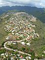
Puʻuikena Drive, the main road through Hawaii Loa Ridge (2008)
-
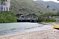
The connection point between Maunalua Bay and Koko Marina
-
Facing Koko Head
-
Facing Diamond Head
-
West side of Maunalua Bay
-
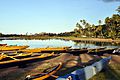
Canoes docked at Maunalua Bay
-
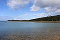
East view of Maunalua Bay looking towards Portlock
-
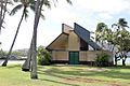
Building at Maunalua Bay Beach Park


See also
 In Spanish: Bahía de Maunalua para niños
