Head Waters, Virginia facts for kids
Quick facts for kids
Head Waters, Virginia
|
|
|---|---|

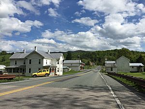
A view of Head Waters, VA eastbound on U.S. 250
|
|
| Country | United States |
| State | Virginia |
| County | Highland |
| Elevation | 2,047 ft (624 m) |
| Time zone | UTC−5 (Eastern (EST)) |
| • Summer (DST) | UTC−4 (EDT) |
| ZIP codes |
24442
|
| GNIS feature ID | 1484004 |
Head Waters (sometimes called Headwaters) is a small place in Highland County, Virginia, United States. It's known as an unincorporated community. This means it's a group of homes and businesses that isn't officially a town or city with its own local government.
Discovering Head Waters
Head Waters is located about 4.25 miles (6.84 km) east of a place called McDowell. You can find it along US 250, which is an important road.
Why is it called Head Waters?
The name "Head Waters" is quite interesting! It comes from a special natural feature nearby. The South Fork South Branch Potomac River actually starts (or "rises") just north of this community. Because the river's "headwaters" (its source) are so close, the community got its unique name.
What's in Head Waters?
Even though it's not a big city, Head Waters has its own post office. This post office uses the ZIP code 24442. It helps people living there send and receive mail.
 | Stephanie Wilson |
 | Charles Bolden |
 | Ronald McNair |
 | Frederick D. Gregory |


