Hedding, New Jersey facts for kids
Quick facts for kids
Hedding, New Jersey
|
|
|---|---|

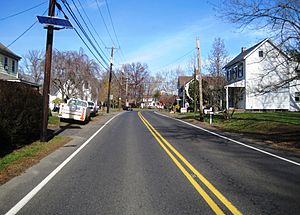
Looking north along Old York Road (CR 660)
|
|
| Country | |
| State | |
| County | Burlington |
| Township | Mansfield |
| Named for | Elijah Hedding |
| Elevation | 25 m (82 ft) |
| Time zone | UTC−05:00 (Eastern (EST)) |
| • Summer (DST) | UTC−04:00 (Eastern (EDT)) |
| Area code(s) | 609, 640 |
| GNIS feature ID | 877031 |
Hedding is a small, quiet community located within Mansfield Township, in Burlington County, New Jersey. It is known as an unincorporated community. This means it is a group of homes and businesses that are part of a larger township, rather than being its own separate town. Hedding has an interesting history with several different names over the years.
Contents
What's in a Name? The History of Hedding
Hedding hasn't always been called Hedding. This community has changed its name a few times!
From Tavern to Tuns
From 1793 to 1813, the area was known as Bryant's Tavern. It was named after William Bryant, who owned a popular tavern there. Imagine a place named after a local hangout!
In 1817, the name changed again to Three Tuns. This name came from a sign outside a local inn or hostelry. The sign showed three large wooden barrels, called "tuns."
Becoming Hedding
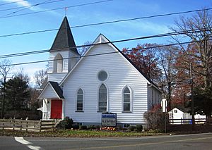
The name changed to Hedding in 1920. This new name came from a church built in the area in 1847. The church was called Hedding Methodist Episcopal Church. It was named in honor of Elijah Hedding, who was an important leader (a Bishop) in that church. So, the community took its name from the church, which was named after a respected bishop.
Life in Hedding
Today, Hedding is mostly made up of single-family houses. These homes are grouped together around the main crossroads in the community. These important roads are Old York Road, also known as County Route 660, and Kinkora Road / Columbus Hedding Road, which is County Route 678.
Outside of the main cluster of houses, much of the surrounding area is still used for farming. This means you can see lots of open fields and farms nearby.
Getting Around
While a major highway, Interstate 295, passes southeast of Hedding, there are no direct exits or entrances into the community from this highway. This helps keep Hedding a quiet place.


