Helena Island facts for kids

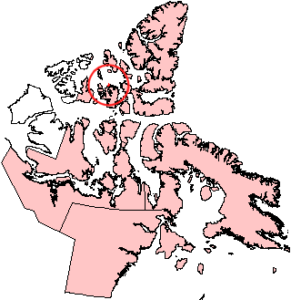
Helena Island, Nunavut.
|
|
| Geography | |
|---|---|
| Location | Northern Canada |
| Coordinates | 76°40′N 101°00′W / 76.667°N 101.000°W |
| Archipelago | Queen Elizabeth Islands Canadian Arctic Archipelago |
| Area | 327 km2 (126 sq mi) |
| Length | 41 km (25.5 mi) |
| Width | 13 km (8.1 mi) |
| Administration | |
|
Canada
|
|
| Territory | Nunavut |
| Region | Qikiqtaaluk |
| Demographics | |
| Population | Uninhabited |
Helena Island is a quiet island in the far north of Canada. It is part of the Canadian Arctic Archipelago, a huge group of islands in the Arctic Ocean. No one lives on Helena Island, making it a wild and natural place.
About Helena Island
Helena Island is located in the Qikiqtaaluk Region of Nunavut, Canada. This territory is in the northern part of Canada. The island is found along the northern coast of Bathurst Island. A narrow body of water called Sir William Parker Strait separates the two islands.
Size and Neighbors
Helena Island covers an area of about 327 square kilometers (about 126 square miles). It is roughly 41 kilometers (25 miles) long and 13 kilometers (8 miles) wide. To its west, you can find Seymour Island.
Important Places on the Island
Even though no one lives on Helena Island, it has some notable points. These are like natural landmarks. In the north, you'll find Devereaux Point. Noel Point is located on the western side of the island. On the southern part of Helena Island, there is a place called Cape Robert Smart.
See also
 In Spanish: Isla Helena (Nunavut) para niños
 | Frances Mary Albrier |
 | Whitney Young |
 | Muhammad Ali |


