Hemlock, Indiana facts for kids
Quick facts for kids
Hemlock, Indiana
|
|
|---|---|

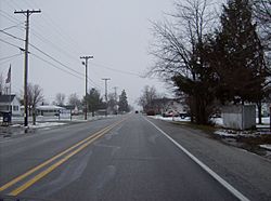
Along State Road 26 in Hemlock
|
|
| Country | United States |
| State | Indiana |
| County | Howard |
| Township | Taylor |
| Elevation | 860 ft (260 m) |
| ZIP code |
46937
|
| Area code(s) | 765 |
| GNIS feature ID | 2830413 |
Hemlock is a small, quiet community located in Indiana, United States. It's not a big city, but an unincorporated community, which means it doesn't have its own local government like a city or town. Hemlock is found in the southern part of Taylor Township, within Howard County. You can find it where State Road 26 crosses County Road 450E.
Hemlock is also considered part of the larger Kokomo Metropolitan Statistical Area. This means it's connected to the economic and social life of the nearby city of Kokomo.
A Look Back: Hemlock's History
The community of Hemlock was first planned and settled in the year 1852. When it was originally established, it had a different name. It was known as Terre Halle. However, before the year 1881, the community's name was changed to Hemlock, which it has been called ever since.
 | Tommie Smith |
 | Simone Manuel |
 | Shani Davis |
 | Simone Biles |
 | Alice Coachman |


