Hilltop, Ohio facts for kids
Quick facts for kids
Hilltop, Ohio
|
||
|---|---|---|
|
||

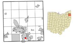
Location of Hilltop in Trumbull County within the state of Ohio
|
||
| Country | United States | |
| State | Ohio | |
| County | Trumbull | |
| Township | Weathersfield | |
| Area | ||
| • Total | 0.75 sq mi (1.94 km2) | |
| • Land | 0.75 sq mi (1.94 km2) | |
| • Water | 0.00 sq mi (0.00 km2) | |
| Elevation | 942 ft (287 m) | |
| Population
(2020)
|
||
| • Total | 658 | |
| • Density | 876.17/sq mi (338.32/km2) | |
| Time zone | UTC-5 (Eastern (EST)) | |
| • Summer (DST) | UTC-4 (EDT) | |
| FIPS code | 39-35613 | |
| GNIS feature ID | 2393051 | |
Hilltop is a small community in Ohio, United States. It is located in Trumbull County, within Weathersfield Township. Hilltop is known as a census-designated place, which means it's a special area defined for gathering population data. In 2020, about 658 people lived there. It is part of the larger Youngstown–Warren metropolitan area.
Hilltop's Location and Size
Hilltop is in central Weathersfield Township. The United States Census Bureau says that Hilltop covers an area of about 0.6 square miles (1.94 square kilometers). All of this area is land, with no large bodies of water.
Hilltop's Population Over Time
The number of people living in Hilltop has changed over the years. Here's a quick look at the population from recent censuses:
| Historical population | |||
|---|---|---|---|
| Census | Pop. | %± | |
| 2000 | 534 | — | |
| 2010 | 532 | −0.4% | |
| 2020 | 658 | 23.7% | |
| U.S. Decennial Census | |||
In 2000, there were 534 people living in Hilltop. These people lived in 199 households, and 160 of these were families. The community is home to people of all ages, including children, teenagers, adults, and seniors.
See also
 In Spanish: Hilltop (Ohio) para niños
 | William M. Jackson |
 | Juan E. Gilbert |
 | Neil deGrasse Tyson |


