Himmelberg facts for kids
Quick facts for kids
Himmelberg
|
||
|---|---|---|
 |
||
|
||
| Country | Austria | |
| State | Carinthia | |
| District | Feldkirchen | |
| Area | ||
| • Total | 56.85 km2 (21.95 sq mi) | |
| Elevation | 672 m (2,205 ft) | |
| Time zone | UTC+1 (CET) | |
| • Summer (DST) | UTC+2 (CEST) | |
| Postal code |
9562
|
|
| Website | www.himmelberg.at | |
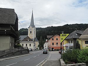
Himmelberg is a small town, also called a municipality, in Austria. It is located in the state of Carinthia, which is in the southern part of Austria. Himmelberg is part of the Feldkirchen district. About 2,273 people live here.
Geography of Himmelberg
Himmelberg is in the middle of Carinthia. It lies to the northwest of a larger town called Feldkirchen. The town is located in a valley known as the Tiebel valley.
Mountains and Rivers
The highest point in Himmelberg is a mountain called the Hoferalmkopf. It is about 1,600 meters (or 5,250 feet) high. This mountain is in the northwest part of the municipality. The lowest point in Himmelberg is the Tiebel River. This river flows at an elevation of about 625 meters (or 2,050 feet) in the southern part of the municipality.
Neighboring Towns
Himmelberg shares its borders with several other towns. To the north, you can find Gnesau and Steuerberg. To the west, it borders Arriach and Steindorf. To the south and east, it is close to Feldkirchen in Kärnten.
See also
 In Spanish: Himmelberg para niños
 | William M. Jackson |
 | Juan E. Gilbert |
 | Neil deGrasse Tyson |


