Hindustan, Indiana facts for kids
Quick facts for kids
Hindustan, Indiana
|
|
|---|---|

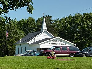
Hindustan Christian Church
|
|
| Country | United States |
| State | Indiana |
| County | Monroe |
| Township | Washington |
| Elevation | 853 ft (260 m) |
| Time zone | UTC-5 (Eastern (EST)) |
| • Summer (DST) | UTC-4 (EDT) |
| ZIP code |
47408
|
| Area code(s) | 812, 930 |
| FIPS code | 18-34042 |
| GNIS feature ID | 436233 |
Hindustan is a small, unincorporated community located in Washington Township, Monroe County, in the U.S. state of Indiana. It is not a city or a town with its own local government, but rather a group of homes and buildings that are part of a larger area.
Contents
A Look Back: Hindustan's Story
Hindustan was officially planned out on August 18, 1853. This process, called "platting," means that someone drew up a map showing how the land would be divided into streets and lots. The person who did this was named Charles G. Carr.
How Hindustan Got Its Name
The community got its name from India, which is sometimes called "Hindustan," or from a specific region within India. It's interesting to see how places in the United States can be named after faraway lands!
Old Spellings of the Name
If you look at old documents from the 1870s, you might see the town's name spelled a little differently. Back then, it was often written as 'Hindostan' instead of 'Hindustan'.
Where is Hindustan Located?
Hindustan is found at an elevation of about 271 meters (which is about 892 feet) above sea level. It sits along a road called Old State Road 37, between two other roads known as Chambers Pike and Farr Road.
Nature Around Hindustan
This community is located inside the Morgan Monroe State Forest. This means it's surrounded by lots of trees and nature, making it a scenic and peaceful place.
 | Dorothy Vaughan |
 | Charles Henry Turner |
 | Hildrus Poindexter |
 | Henry Cecil McBay |


