Hlubeck Glacier facts for kids
Quick facts for kids Hlubek Glacier |
|
|---|---|

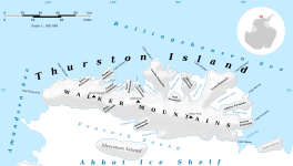
Map of Thurston Island
|
|
| Type | tributary |
| Location | Ellsworth Land |
| Coordinates | 72°30′00″S 97°09′00″W / 72.50000°S 97.15000°W |
| Length | 9 nautical miles (17 km; 10 mi) |
| Thickness | unknown |
| Terminus | Abbot Ice Shelf |
| Status | unknown |
The Hlubek Glacier (72°30′S 97°9′W / 72.500°S 97.150°W) is a large river of ice found in Antarctica. It stretches about 9 nmi (17 kilometers) long. This glacier is located on the southeast side of Thurston Island, which is a big island covered in ice.
Where is Hlubek Glacier Located?
Hlubek Glacier is in a part of Antarctica called Ellsworth Land. It flows towards the south, moving along the eastern edge of a place called Shelton Head. Eventually, this massive ice river flows into the Abbot Ice Shelf. An ice shelf is a thick, floating platform of ice that forms where a glacier flows off land into the ocean.
How Hlubek Glacier Got Its Name
This glacier was named by the Advisory Committee on Antarctic Names. They chose the name to honor Vernon R. Hlubeck. He was an aviation radioman, which means he helped with radio communications on airplanes. Vernon Hlubeck was part of a special U.S. Navy mission called Operation Highjump.
What Was Operation Highjump?
Operation Highjump took place in 1946–47. During this mission, airplanes flew over Thurston Island and the nearby coastlines. Their main goal was to take aerial photographs. These photos helped scientists and mapmakers understand the geography of this icy region much better. Vernon Hlubeck was an important part of the aircrew that helped gather these valuable images.


