Hoʻolehua, Hawaii facts for kids
Quick facts for kids
Hoʻolehua, Hawaii
|
|
|---|---|

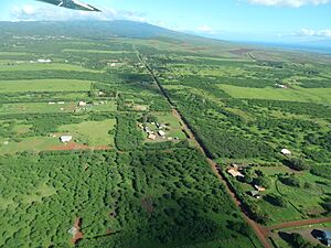
Aerial view
|
|
| Country | United States |
| State | Hawaii |
| County | Maui |
| Elevation | 620 ft (190 m) |
| Time zone | UTC-10 (Hawaii-Aleutian (HST)) |
| ZIP codes |
96729
|
| GNIS feature ID | 359414 |
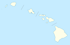
Hoʻolehua (pronounced ho-oh-leh-HOO-wah) is a small community located on the island of Molokaʻi in Maui County, Hawaii. It is considered an "unincorporated community," which means it does not have its own local government like a city or town.
Hoʻolehua is also known as a "Hawaiian home land." This means the land is set aside for native Hawaiians. The community is found near Hawaii Route 460 and right next to the Molokai Airport. It sits at an elevation of about 620 feet (189 meters) above sea level.
About the Name
The name of the community, Hoʻolehua, has been spelled in different ways over time. To make sure everyone uses the same spelling, the United States Board on Geographic Names officially decided on "Hoʻolehua" in 2003. This helps with maps and other official documents.
Post Office and the Post-a-Nut Program
Hoʻolehua has its own post office with the ZIP code 96729. This post office is famous for a special program called "Post-a-Nut." Since 1991, people can send coconuts through the mail for free!
To send a coconut, you simply write the address on the coconut shell itself. Then, you pay for the postage, just like a regular letter or package. About 3,000 coconuts are mailed from Hoʻolehua to places all around the world every year. It's a fun and unique way to send a piece of Hawaii to friends and family.
See also
 In Spanish: Hoolehua (Hawái) para niños
 | Jackie Robinson |
 | Jack Johnson |
 | Althea Gibson |
 | Arthur Ashe |
 | Muhammad Ali |


