Hole of Horcum facts for kids
Quick facts for kids Hole of Horcum |
|
|---|---|

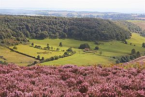
Hole of Horcum from the North with flowering heather in the foreground, August 2017
|
|
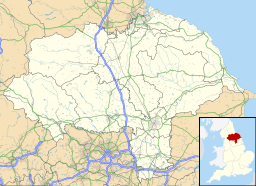
| Location | North Yorkshire, England |
| OS grid | SE845935 |
| Coordinates | 54°19′53″N 0°42′04″W / 54.331266°N 0.701168°W |
Imagine a giant, natural bowl carved into the earth! That's what the Hole of Horcum is. It's a huge, round valley located in the beautiful North York Moors National Park in northern England. You can find it near the villages of Levisham and Lockton. This amazing natural wonder is a popular spot for hikers and nature lovers.
Contents
What's in a Name?
The name 'Hole of Horcum' might sound a bit strange! Long ago, people called it things like Hotcumbe or Horcombe. The first part, 'Horcum', comes from an old English word meaning 'filth' or 'dirt'. The second part, 'cumb', comes from an ancient Celtic language and means 'bowl-shaped valley'. So, the name basically describes a "dirty bowl-shaped valley," which probably refers to the muddy ground or how it looked long ago.
How the Hole Was Formed
The Hole of Horcum is truly massive! It's about 120 meters (400 feet) deep and stretches about 1.2 kilometers (¾ mile) across. It wasn't dug out by a giant, but by a slow, natural process called spring-sapping.
What is Spring-Sapping?
Spring-sapping happens when water from underground springs slowly wears away the hillside. Imagine water bubbling up from the ground. Over thousands of years, this water gradually washes away tiny bits of rock and soil. This makes the slopes above weaker and weaker.
A Giant Natural Bowl
Because of spring-sapping, a once narrow valley slowly grew wider and deeper. It turned into the enormous, bowl-shaped hollow you see today. This process is still happening, so the Hole of Horcum is always changing, even if it's too slow for us to notice!
The Legend of Wade the Giant
Local stories often explain natural wonders with exciting tales. One legend says that the Hole of Horcum was created by a giant named Wade. The story goes that Wade was arguing with his wife. In a fit of anger, he scooped up a huge handful of earth and threw it at her! That giant scoop of earth is said to have formed the Hole of Horcum. It's a fun way to imagine how such a big hole could have appeared!
 | Mary Eliza Mahoney |
 | Susie King Taylor |
 | Ida Gray |
 | Eliza Ann Grier |


