
Holzminden (district) facts for kids
Quick facts for kids
Holzminden
|
||
|---|---|---|
|
||
| Country | ||
| State | Lower Saxony | |
| Capital | Holzminden | |
| Area | ||
| • Total | 692 km2 (267 sq mi) | |
| Population
(2002)
|
||
| • Total | 80,300 | |
| • Density | 116.04/km2 (300.5/sq mi) | |
| Time zone | UTC+1 (CET) | |
| • Summer (DST) | UTC+2 (CEST) | |
| Vehicle registration | HOL | |
| Website | landkreis-holzminden.de | |

Holzminden is a district in Lower Saxony, Germany. Think of a district like a county or a region that groups several towns and villages together. It's a way to organize local government and services.
This district is located in the beautiful Weserbergland mountains. The Weser River flows along the southwestern edge of the district. This area is known for its rolling hills and forests.
What is a District?
In Germany, a "district" (called a Landkreis) is a type of local government area. It's bigger than a single city but smaller than a state. The district government helps manage things like schools, roads, and public services for all the towns and villages within its borders.
The main office, or "capital," of the Holzminden district is the town of Holzminden. This is where many of the district's important decisions are made.
Towns and Communities
The Holzminden district is made up of several towns and many smaller communities. These communities work together under the district's guidance.
Some of the main towns and groups of communities in the district include:
- Holzminden (the capital town)
- Delligsen (a free municipality)
- Bevern (a group of communities)
- Bodenwerder-Polle (another group of communities)
- Boffzen (a group of communities)
- Eschershausen-Stadtoldendorf (a group of communities)
These groups of communities, called Samtgemeinden, help manage local services more easily. Each Samtgemeinde has a main town where its offices are located.
Images for kids
-
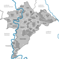
This map shows the different towns and communities in the Holzminden district.

See also
 In Spanish: Distrito de Holzminden para niños
