Horine, Missouri facts for kids
Quick facts for kids
Horine, Missouri
|
|
|---|---|

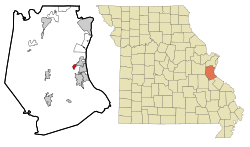
Location of Horine, Missouri
|
|
| Country | United States |
| State | Missouri |
| County | Jefferson |
| Area | |
| • Total | 0.72 sq mi (1.86 km2) |
| • Land | 0.71 sq mi (1.85 km2) |
| • Water | 0.01 sq mi (0.02 km2) |
| Elevation | 502 ft (153 m) |
| Population
(2020)
|
|
| • Total | 657 |
| • Density | 922.75/sq mi (356.07/km2) |
| Time zone | UTC-6 (Central (CST)) |
| • Summer (DST) | UTC-5 (CDT) |
| ZIP code |
63070
|
| Area code(s) | 636 |
| FIPS code | 29-33040 |
| GNIS feature ID | 2393054 |
Horine is a small community in Jefferson County, Missouri, United States. It is an unincorporated community, which means it does not have its own local government like a city or town. It is also a census-designated place (CDP). This means the government counts it as a separate place for population statistics.
In 2010, about 821 people lived in Horine. By 2020, the population had decreased to 657 people.
Contents
History of Horine
Horine was officially mapped out in 1868. It was named after C. Thomas Horine, who was one of the first people to settle in the area.
A post office, which is a place where mail is sent and received, was opened in 1862. It was first called "Horine Station." In 1916, its name was changed to "Horine." The post office eventually closed in 1942.
Geography and Location
Horine is located in the eastern part of Jefferson County. It is near several other places and natural features.
To the northeast, Horine is next to the city of Pevely. To the northwest, it is bordered by Route Z, which is a type of road. To the south, you'll find Joachim Creek. This creek flows directly into the mighty Mississippi River.
Area and Water Features
The United States Census Bureau measures the size of places like Horine. The Horine CDP covers a total area of about 1.96 square kilometers (or 0.76 square miles). Most of this area is land, about 1.94 square kilometers (0.75 square miles).
A small part of Horine's area is water, about 0.02 square kilometers (0.01 square miles). This means that about 0.98% of Horine's total area is water. The size of the CDP has become a little smaller since 2000. This is because some parts of Horine were officially added to the city of Pevely.
Population Information
| Historical population | |||
|---|---|---|---|
| Census | Pop. | %± | |
| 2020 | 657 | — | |
| U.S. Decennial Census | |||
Understanding the population helps us learn about the people who live in Horine. In 2000, there were 923 people living in the Horine CDP. These people lived in 335 different homes, and 254 of these were families.
The population density was about 1,112 people per square mile. This tells us how many people live in a certain amount of space. There were also 355 housing units, which are places where people can live.
Age and Gender in Horine
The population of Horine is made up of people of different ages. In 2000:
- About 24.3% of the people were under 18 years old.
- About 10.0% were between 18 and 24 years old.
- About 31.9% were between 25 and 44 years old.
- About 24.8% were between 45 and 64 years old.
- About 9.1% were 65 years old or older.
The average age of people in Horine was 36 years old. For every 100 females, there were about 108.8 males. This means there were slightly more males than females in the community.
Education in Horine
Students living in Horine attend schools that are part of the Dunklin R-V School District. This district is responsible for providing public education to the children in the area.
See also
 In Spanish: Horine (Misuri) para niños

