Horse Shoe Curve, Virginia facts for kids
Quick facts for kids
Horse Shoe Curve, Virginia
|
|
|---|---|
|
Unincorporated community
|
|
| Country | United States |
| State | Virginia |
| County | Clarke |
| Elevation | 738 ft (225 m) |
| Time zone | UTC-5 (Eastern (EST)) |
| • Summer (DST) | UTC-4 (EDT) |
| Area code(s) | 540 |
| GNIS feature ID | 1802675 |
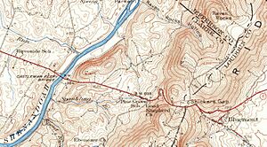
Horse Shoe Curve is a small, unnamed place in Clarke County, Virginia, United States. It's known as an "unincorporated community," which means it's a group of homes or businesses that isn't officially a town or city. This area gets its name from a special bend in the road, much like the shape of a horse's shoe.
Contents
Discovering Horse Shoe Curve
Horse Shoe Curve is a unique spot in Virginia. It's not a big city, but a quiet area. It's located about 7 miles (11 km) east-southeast of Berryville.
What's an Unincorporated Community?
An unincorporated community is a place where people live, but it doesn't have its own local government. It's part of a larger county. So, Horse Shoe Curve is part of Clarke County. The county government takes care of services like roads and schools.
The Famous Curve
The name "Horse Shoe Curve" comes from a distinctive bend in Route 679. This part of the road curves sharply, looking like a horseshoe. It's a notable feature for drivers and locals.
A Bit of History
This area has been around for a while. Since the early 1900s, there has been a tavern in Horse Shoe Curve. Taverns were important gathering places back then. They offered food, drinks, and a place for travelers to rest.


