Berryville, Virginia facts for kids
Quick facts for kids
Berryville, Virginia
|
|||||
|---|---|---|---|---|---|
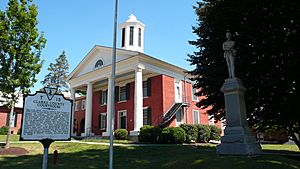
The Clarke County Courthouse in Berryville
|
|||||
|
|||||
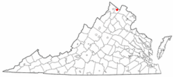
Location of Berryville in Virginia
|
|||||
| Country | |||||
| State | |||||
| County | |||||
| Area | |||||
| • Total | 2.27 sq mi (5.88 km2) | ||||
| • Land | 2.27 sq mi (5.88 km2) | ||||
| • Water | 0.00 sq mi (0.00 km2) | ||||
| Elevation | 591 ft (180 m) | ||||
| Population
(2010)
|
|||||
| • Total | 4,185 | ||||
| • Estimate
(2019)
|
4,371 | ||||
| • Density | 1,926.40/sq mi (743.73/km2) | ||||
| Time zone | UTC−5 (Eastern (EST)) | ||||
| • Summer (DST) | UTC−4 (EDT) | ||||
| ZIP code |
22611
|
||||
| Area code(s) | 540 | ||||
| FIPS code | 51-06968 | ||||
| GNIS feature ID | 1498453 | ||||
Berryville is a small town in Virginia, United States. It is the main town and county seat of Clarke County. In 2020, about 4,574 people lived there. This was a bit more than the 4,185 people counted in 2010.
Contents
History of Berryville
Berryville started where two important roads met: the Winchester Turnpike and Charlestown Road. The land was first given to Captain Isaac Pennington in 1734. Later, in 1750, George Washington himself surveyed the area.
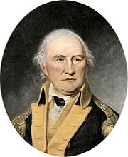
A fun story says that Daniel Morgan, an early resident, used to have friendly fights with young people at this crossroads. He would even pile up stones to use if needed! Because of these lively gatherings and a noisy tavern nearby, the area was first called "Battle Town".
In 1765, Major Charles Smith bought the land. He also called his property "Battle Town". He built a house where the old tavern used to be. This house, called "The Nook", is still standing on Main Street today.
Daniel Morgan became famous after fighting in the American Revolution. He returned to the area and often visited the new tavern, which is now the Battletown Inn.
In 1797, Major Smith's son, John Smith, sold some land to Benjamin Berry and Sarah (Berry) Stribling. They divided the land into smaller pieces to create a town. On January 15, 1798, the town of Berryville was officially founded.
By 1810, Berryville had grown to include at least 25 homes, three stores, a pharmacy, two taverns, and a school. It became the main town for the new Clarke County in 1836.
During the American Civil War, in 1864, a battle called the Battle of Berryville was fought in and around the town. The railroad reached Berryville in the 1870s, which helped the town grow.
Harry F. Byrd, who was a governor and a U.S. senator for Virginia, lived in Berryville for a long time. He built a log cabin called "Westwood" and later moved to a large estate called Rosemont, next to his family's apple orchards.
Geography and Location
Berryville is located in the northern part of the Shenandoah Valley. It is about 11 miles (18 km) east of Winchester. The town is also about 5 miles (8 km) south of the West Virginia border.
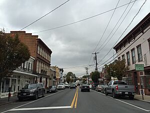
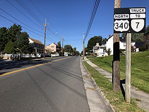
U.S. Route 340 goes through the middle of Berryville. This road leads northeast to Charles Town, West Virginia and southwest to Front Royal. Virginia State Route 7 is a four-lane highway that goes around the northern edge of Berryville. It connects west to Winchester and east to Leesburg, crossing the Blue Ridge Mountains.
The United States Census Bureau says that Berryville covers a total area of 2.27 square miles (5.9 square kilometers), and all of it is land.
Population Information
| Historical population | |||
|---|---|---|---|
| Census | Pop. | %± | |
| 1860 | 356 | — | |
| 1870 | 580 | 62.9% | |
| 1900 | 938 | — | |
| 1910 | 876 | −6.6% | |
| 1920 | 1,138 | 29.9% | |
| 1930 | 1,094 | −3.9% | |
| 1940 | 1,262 | 15.4% | |
| 1950 | 1,401 | 11.0% | |
| 1960 | 1,645 | 17.4% | |
| 1970 | 1,569 | −4.6% | |
| 1980 | 1,752 | 11.7% | |
| 1990 | 3,097 | 76.8% | |
| 2000 | 2,963 | −4.3% | |
| 2010 | 4,185 | 41.2% | |
| 2020 | 4,574 | 9.3% | |
| U.S. Decennial Census | |||
In 2000, there were 2,963 people living in Berryville. The town had 1,239 households. About 28.6% of these households had children under 18 living with them. The average age of people in Berryville was 41 years old.
Transportation in Berryville
Berryville is located where U.S. Route 340 and Virginia State Route 7 meet. US 340 goes through the center of town. It connects Berryville to Front Royal to the southwest and Charles Town to the northeast.
State Route 7 (SR 7) goes around the town to the north. It connects Berryville to Winchester in the west and Leesburg in the east. US 340 also connects to Interstate 66 near Front Royal. SR 7 connects to Interstate 81 near Winchester. While SR 7 now bypasses downtown Berryville, SR 7 Business still runs through the town on Main Street.
Schools in Berryville
Berryville has several schools for students of different ages:
- D.G. Cooley Elementary School
- Johnson Williams Middle School
- Clarke County High School
Climate
The weather in Berryville has hot, humid summers. Winters are usually mild to cool. This type of weather is known as a humid subtropical climate.
| Climate data for Berryville, Virginia | |||||||||||||
|---|---|---|---|---|---|---|---|---|---|---|---|---|---|
| Month | Jan | Feb | Mar | Apr | May | Jun | Jul | Aug | Sep | Oct | Nov | Dec | Year |
| Record high °F (°C) | 76 (24) |
81 (27) |
86 (30) |
93 (34) |
95 (35) |
99 (37) |
102 (39) |
103 (39) |
102 (39) |
92 (33) |
85 (29) |
78 (26) |
103 (39) |
| Mean daily maximum °F (°C) | 40 (4) |
45 (7) |
54 (12) |
65 (18) |
74 (23) |
82 (28) |
86 (30) |
84 (29) |
78 (26) |
66 (19) |
55 (13) |
45 (7) |
65 (18) |
| Daily mean °F (°C) | 31 (−1) |
35 (2) |
43 (6) |
53 (12) |
62 (17) |
71 (22) |
75 (24) |
73 (23) |
67 (19) |
54 (12) |
45 (7) |
36 (2) |
54 (12) |
| Mean daily minimum °F (°C) | 21 (−6) |
24 (−4) |
31 (−1) |
40 (4) |
50 (10) |
59 (15) |
64 (18) |
62 (17) |
55 (13) |
42 (6) |
34 (1) |
26 (−3) |
42 (6) |
| Record low °F (°C) | −13 (−25) |
−10 (−23) |
−5 (−21) |
18 (−8) |
26 (−3) |
37 (3) |
42 (6) |
39 (4) |
28 (−2) |
17 (−8) |
6 (−14) |
−8 (−22) |
−13 (−25) |
| Average precipitation inches (mm) | 2.8 (71) |
2.4 (61) |
3.1 (79) |
3.0 (76) |
3.7 (94) |
3.5 (89) |
4.1 (100) |
3.3 (84) |
3.3 (84) |
3.4 (86) |
3.1 (79) |
2.5 (64) |
38.2 (967) |
| Source: weather.com | |||||||||||||
Interesting Places in Berryville
Here are some notable buildings and places in Berryville:
- J & L Pie Co. - This company has been making pies since 1899!
- Clarke County High School
- Holy Cross Abbey - This is a monastery where monks live.
- Soldier's Rest - A historic building from 1769.
- Historic Rosemont Manor - This was once the home of Governor and U.S. Senator Harry F. Byrd.
Many other places in and around Berryville are listed on the National Register of Historic Places. This means they are important for their history or architecture. Some of these include the Berryville Historic District, Chapel Hill, Clermont, Cool Spring Battlefield, Fairfield, Glendale Farm, Josephine City School, Long Marsh Run Rural Historic District, Norwood, Old Clarke County Courthouse, Smithfield Farm, and Wickliffe Church.
Famous People from Berryville
- Harry F. Byrd: A former governor and U.S. senator for Virginia.
- Rennie Davis: An organizer against war in the 1960s.
- Drew Gilpin Faust: A past president of Harvard University.
- James Noble: The first U.S. senator for Indiana.
- Noah Noble: James Noble's brother and a former governor of Indiana.
- Forrest Pritchard: A best-selling author and farmer who focuses on sustainable farming.
- Oliver North: A former U.S. Marine Corps officer and TV analyst.
- Lloyd W. Williams: A Marine officer who served in World War I. He is famous for saying, "Retreat? Hell, we just got here!"
See also
 In Spanish: Berryville (Virginia) para niños
 | Precious Adams |
 | Lauren Anderson |
 | Janet Collins |


