
Hotham Heights facts for kids


Hotham Heights is a special area found on the western side of Weddell Island. Weddell Island is one of the many islands that make up the Falkland Islands, located in the South Atlantic Ocean. Hotham Heights is like a raised area or a small mountain range.
What are Hotham Heights?
Hotham Heights stretches out for about 9 kilometers (about 5.6 miles) from the southwest to the northeast. It is also about 6 kilometers (about 3.7 miles) wide from the southeast to the northwest. The highest point in Hotham Heights is called Chatham Hill, which reaches a height of 236 meters (about 774 feet). That's taller than many buildings!
This area is located at coordinates 51°52′10″ South and 61°04′30″ West. These numbers help people find the exact spot on a map, just like an address helps you find a house.
Exploring the Area
People who want to learn more about Weddell Island and Hotham Heights can look at different maps. These maps help explorers and scientists understand the land. Some old maps, like one from 1901, show how the island looked a long time ago.
- You can see an old map of the Falkland Islands here: The Falkland Islands (1901 map)
Gallery
-
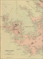
An old map of Weddell Island, showing Chatham Harbour.
-
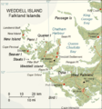
A more recent map of Weddell Island.


