
Weddell Island facts for kids

Satellite image of Weddell Island
|
|

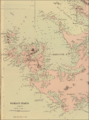
Location in the Southwest Atlantic
|
|
| Etymology | Named after James Weddell |
|---|---|
| Geography | |
| Location | South Atlantic Ocean |
| Coordinates | 51°52′43″S 61°00′24″W / 51.87861°S 61.00667°W |
| Archipelago | Falklands Archipelago Weddell Island Group |
| Total islands | 23 |
| Major islands | Weddell, Bald, Barclay, Carthorse, Circum, Fox, Hill, Low, Penn, Pitt, Quaker |
| Area | 265.8 km2 (102.6 sq mi) |
| Length | 26.8 km (16.65 mi) |
| Width | 22.4 km (13.92 mi) |
| Coastline | 175.7 km (109.17 mi) |
| Highest elevation | 383 m (1,257 ft) |
| Highest point | Mount Weddell |
| Administration | |
|
|
|
| Constituency | Camp |
| Statistical region | Outlying Islands |
| Largest settlement | Weddell Settlement |
| Demographics | |
| Population | 43 (2016) Population number is for all Outlying Islands |
| Languages | English |
| Ethnic groups | Falkland Islanders |
| Additional information | |
| Time zone |
|
Weddell Island (called Isla San José in Spanish) is one of the Falkland Islands. It is located in the South Atlantic Ocean, southwest of West Falkland. This island is about 1545 km (960 mi) west-northwest of South Georgia Island. It is also 606 km (377 mi) northeast of Cape Horn.
Weddell Island is the third largest island in the Falklands. It covers an area of 265.8 square kilometers (102.6 sq mi). It is also one of the biggest private islands in the world. Only a few people live in Weddell Settlement, the island's only inhabited place. They mostly work in sheep farming and tourism.
The island is a great place for walks and seeing wildlife. You can also enjoy amazing views, including the famous Falklands stone runs. Weddell Island is important for plants and animals. It is known as an Important Plant Area and a Key Biodiversity Area.
Weddell Island is quite remote. A supply ship visits it sometimes. Private yachts also stop by. You can fly there from Stanley, the capital of the Falklands. The flight is about 200 km (124 mi) long.
Contents
What's in a Name?
Until the mid-1800s, Weddell Island was called Swan Island. No one knows for sure where this name came from. Captain George Dixon, a sailor who worked with James Cook, recorded the name in 1785. He found it amusing, along with other Falklands names.
The island might have been named after the Black-necked swan, a local bird. Some old French and Spanish maps called it 'Island(s) of Swans'. This suggests the name was about birds, not a person or ship.
The island's current name comes from James Weddell. He was a British sealer and explorer. He visited the Falklands between 1819 and 1824. He even stayed on the island twice, including in 1823 at Quaker Harbour. Weddell wrote a book called A Voyage Towards the South Pole. It shared stories about the local history.
James Weddell is famous for his trips to the Antarctic. Many places and animals are named after him. These include the Weddell Seal, Weddell Sea, and Weddell Point.
Island's Past
How Weddell Island Was Found
.jpg)


The British sailor John MacBride discovered Weddell Island in 1766. He was mapping the Falkland Islands with his ship HMS Jason. They sailed from Port Egmont, an early British settlement. MacBride described the islands as "a mass of islands and broken lands, beaten by storms."
His map of the Falklands was very accurate for its time. Captain James Cook later used MacBride's map for his own chart in 1777.
The French, who started the first Falklands settlement in 1764, did not know about the island. The Spanish first saw Weddell Island in 1769. This was during an overland trip across West Falkland. In 1770, Captain Manuel Pando explored the island. His map called the group of islands Yslas de San Miguel. The large bay was named Puerto de San Joseph. This name later became Isla San José for the island itself.
Early Days on the Island
The first people to live on the island were seal hunters. They started hunting seals in the 1770s. American and British sealers often visited Weddell and nearby islands. They would stay for long periods, sometimes even through the winter.
The sealers liked Weddell Island for several reasons. It had many safe harbors from storms. It was also far from the Spanish settlement, which was not friendly to sealers. After the Spanish left in 1811, sealers spread across the Falklands.
Weddell Island was also a good stop for trips to Antarctica. From here, they could sail to new hunting grounds. Many place names around Weddell Island honor these early sealers.
In 1831, the US Navy protected American seal hunting from Argentina. This event helped lead to Britain taking back control of the Falkland Islands in 1833.
A Real-Life Castaway Story

In a famous story, an American sealer named Captain Charles Barnard was stranded on Weddell Island. He was there from June 1813 to November 1814. He was with four sailors and his helpful dog, Cent. They had a small whaleboat.
The castaways built shelters and hunted wild pigs. They also collected wood to survive. One sailor, Ansel, became difficult. He was sent to live alone at Quaker Harbour for a while. Barnard found two graves there, which were very old.
James Weddell met Barnard in 1821. He later shared Barnard's story in his book. Barnard then wrote his own book, Narrative of Sufferings and Adventures, in 1829. He wanted to correct some mistakes in Weddell's story.
Barnard later became important in Antarctic sealing. Places like Barnard Point are named after him. He also named two places near Weddell Island after himself.
Falklands War Impact
Weddell Island was not occupied by Argentine troops during the 1982 Falklands War. It was also mostly untouched by fighting. No land mines or naval mines were placed in the area.
On June 5, 1982, the submarine HMS Onyx hit a rock near Cape Meredith. It was carrying a special team of six soldiers. They were going to Weddell Island to look for enemy posts. Luckily, there were none.
Shipwrecks and Burials
Five ships have been lost in the waters around Weddell Island. These include the schooner Castalia in 1893 and the cutter Messenger in 1920.
There are 16 recorded graves on the island. The earliest two were found by Barnard in 1813. Half of them are in the Weddell Settlement Cemetery. The first burial there was in 1889. Some deaths happened because there was little medical help in such remote places.
Island's Shape and Land

Weddell Island is bordered by Queen Charlotte Bay to the east. Smylie Channel is to the south. Many smaller islands surround it. These include Dyke Island, Sea Dog Island, and Beaver Island.
The island looks like an upside-down triangle. Chatham Harbour almost cuts it in half. Weddell Island is 26.8 km (16.7 mi) long from south to north. It is 22.4 km (13.9 mi) wide from east to west. Its coastline is very curvy, stretching 175.7 km (109.2 mi).
Most of the island is hilly, except for a flat part in the northeast. Pitt Heights are in the northwest. Hotham Heights are in the west. The highest point is Mount Weddell, which is 383 meters (1,257 ft) tall.
Island Weather
Weddell Island has a maritime climate. This means it's influenced by the ocean. It's a bit warmer and drier than Stanley. The average yearly temperature is about 6°C (43°F). It gets about 500 mm (20 in) of rain each year.
The temperature doesn't change much between summer and winter. The warmest months are January and February. The coldest are June and July. The biggest temperature difference is only 9°C (16.2°F). The coldest temperature recorded was -7.2°C (19°F). The warmest was 22.2°C (72°F).
Amazing Stone Runs

The Falkland Islands have unique landscapes because of the last Ice Age. Even though there were not many glaciers, the islands were very cold. Strong icy winds battered them. This caused rocks to break apart from freezing and thawing. This created the amazing stone runs.
These stone runs are like rivers of rocks. They were first noticed in 1764. Antoine-Joseph Pernety, a naturalist, wrote about them. He said they were "innumerable quantity of stones of all sizes, overthrown on each other."
Charles Darwin visited the Falklands twice. He was very interested in the stone runs. He wrote that the valleys were covered by "myriads of great loose angular fragments." He described them as "streams of stones." He even found shelter under one of the huge rocks during a rain shower.
The Falkland Islands have some of the most special stone runs in the world. They form in certain types of rock. One very long stone river on Weddell Island is 4.3 km (2.7 mi) long. It stretches from a plateau near Mount Weddell.
Plants and Animals

.jpg)
Weddell Island is famous for its wildlife. You can see penguins, sealions, dolphins, and many birds. Some animals, like the wild pigs, were brought to the island long ago.
Other animals were introduced in the 1930s by the island's owner, John Hamilton. These included skunks, rheas, parrots, and guanacos. Patagonian foxes are still found there. There are plans to remove them because they are not native. Past attempts to remove them have not worked.
Other animals that might be removed are house mice and feral cats. These were likely brought by early sealers. Norwegian rats are also present. Removing them would be a big job because the island is so large. Some reindeer are on the island, but they are not breeding. They were brought from South Georgia before being removed from there.
Many non-native plants grow on Weddell Island. Some are invasive. Monterey cypress trees grow in Weddell Settlement. Long hedges of European gorse are also common. These were planted to protect against wind. Gorse is spreading and needs to be controlled. Other invasive plants include Calafate and Creeping thistle.
Scientists say Weddell Island is an Important Plant Area and a Key Biodiversity Area. This means it needs protection. A survey found 114 native plant species on the island. It also has 12 plant species found nowhere else. Four of these are endangered. The island also has a large number of Southern giant petrels, which is important globally.
Who Owns and Runs the Island?
Island Ownership
Weddell Island has been owned by several families over the last 150 years. These include the Williams, Hamilton, Ferguson, Visick, and Clifton families. The current owners are the Clifton brothers, Lewis and Stephen, since 2015.
Weddell Island is one of the biggest private islands in the world. It covers 265.8 square kilometers (102.6 sq mi). Some islands in Hawaii, like Niihau and Lanai, are also private. Niihau is smaller, but Lanai is bigger.
Island Government
Weddell Island is part of the Camp area in the Falkland Islands. This area includes all the country outside of Stanley. It elects three members to the Legislative Assembly of the Falkland Islands. Currently, these are Roger Edwards, Ian Hansen, and Teslyn Barkman.
For statistics, Weddell is part of the Outlying Islands region. This region covers 1033 square kilometers (399 sq mi). In 2016, it had a population of 43 people.
Island Life and Work
In the 1800s, seal hunting became less popular. Sheep farming then became the main business in the Falklands. Sheep farming started on Weddell Island in 1871. The Williams family bought the island and started the farm. Weddell Settlement has been lived in ever since.

The small number of people on the island live in Weddell Settlement. The rest of the island is used for sheep farming and as wild land. The number of sheep has changed a lot over the years. Now, there are about 600 to 700 sheep. Sheep farming is now only done in the Mark Point Paddocks.
Tourists can enjoy walks from Weddell Settlement. They can visit places like Mount Weddell for views. They can also see wildlife at Loop Head or Hell's Kitchen Cove. Most tourist activities are in the northeast part of the island. The rest of Weddell Island is rarely visited. This makes it one of the wildest large Falkland Islands.
The island's tourist attractions also include the amazing Falklands stone runs. These rock formations interested Charles Darwin a lot. Walking on the stone runs can be challenging. However, the rocks are usually stable, making it safe. The island's land is mostly hilly and well-drained. It does not have many boggy areas like other parts of the Falklands.
The buildings for tourists and farming in Weddell Settlement are being updated. The Weddell Lodge is being made bigger for more visitors and workers. Other places to stay include Mountain View Cottage and Sea View Cottage. Old, empty houses in remote areas show where sheep used to be kept across the whole island.
Wind turbines and solar panels provide electricity to four houses in Weddell Settlement. Diesel generators also help when needed.
Getting Around and Communicating
.jpg)

Weddell Island has an airfield about 2.3 km (1.4 mi) north of Weddell Settlement. It has two grass runways. The Falkland Islands Government Air Service (FIGAS) uses small planes to fly from Stanley Airport. The flight to Stanley Airport is about 217 km (135 mi).
For sea travel, there is a 50-meter (164 ft) wooden pier in Weddell Settlement. A ramp is also being built. A supply ship, MV Concordia Bay, visits the island about every 40 days.
One special ship linked to Weddell Island was the Feuerland. This German ship was used by the aviator Gunther Plüschow for his explorations. In 1929, John Hamilton bought it and renamed it Penelope. It was based at Weddell Island until the 1950s. The ship sailed around the Falklands for many years. In 2006, it was moved back to Germany as a historic monument.
People travel on the island by foot, horse, or off-road vehicles. There are two unpaved dirt roads. One goes north for 13 km (8 mi) towards the airfield and Loop Head. The other goes west for 15 km (9 mi), around Chatham Harbour.
Images for kids
-
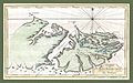
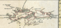
A 1767 map of the Falkland Islands by the French cartographer Étienne André Philippe
-
Weddell Island (marked 'Unknown island') on a Spanish map from after 1769
-
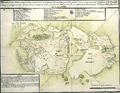
Weddell Island (part of 'Yslas de San Miguel') on a 1770 map by Joseph Antonio Puig
-
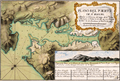
A large map of Chatham Harbour from after 1770
-
Weddell Island (without a name) on a 1777 map by James Cook
-
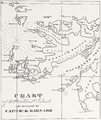
A Falklands map by Charles Barnard from before 1829
-
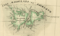
Île Swan (present Weddell Island) on an 1827 French map of the Falklands
-
A part of an 1841 Falkland Islands map by John Arrowsmith
-
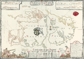
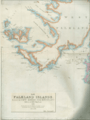
A detailed old map of Weddell Island from 1901


See also
 In Spanish: Isla San José (Malvinas) para niños
