
Quaker Harbour facts for kids


Quaker Harbour is a special bay on the north coast of Weddell Island in the Falkland Islands. It's shaped a bit unevenly and stretches inland for about 3.7 kilometers (about 2.3 miles). A small stream called Pitt Creek flows into the very end of the bay. The bay gets its name from a nearby piece of land called Quaker Island.
Contents
What is Quaker Harbour?
Quaker Harbour is a unique bay found on the northern side of Weddell Island. This island is part of the Falkland Islands, which are located in the South Atlantic Ocean. The bay has an interesting, irregular shape and reaches about 3.7 kilometers (2.3 miles) into the land. Its exact center is at 51°49′00″S 61°04′35″W / 51.81667°S 61.07639°W.
Where is it Located?
The bay is located on the north coast of Weddell Island. This island is one of the many islands that make up the Falkland Islands. A small waterway known as Pitt Creek flows into the very end of Quaker Harbour. The bay was named after Quaker Island, which is very close by.
A Bit of History: James Weddell
A famous British explorer named James Weddell visited the Falkland Islands a long time ago, between 1819 and 1824. He was also an explorer of the Antarctic region. During his travels, James Weddell spent a winter on Weddell Island. At that time, the island was known as Swan Island. He stayed at Quaker Harbour from May to September in 1823.
Images for kids
-
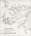
Swan Island (present Weddell Island) and Quaker Harbour on an old Falklands map by Charles Barnard
-
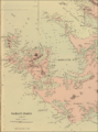
Old map of Weddell Island featuring Quaker Harbour
-
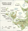
Map of Weddell Island


See also
 In Spanish: Bahía de la Plata para niños
