
Chatham Harbour, Weddell Island facts for kids


Chatham Harbour is a big bay that cuts into the middle of Weddell Island in the Falkland Islands. It used to be called States Bay. In Spanish, it was known as Puerto de San Joseph or Puerto de San José.
You can enter the bay from the east of Beacon Point and west of Loop Head. This wide bay is about 3 kilometers (almost 2 miles) across. It stretches 5 kilometers (about 3 miles) to the southeast. This part of the bay is a safe place for ships to anchor, and it's called Bald Road. North of Clay Point, the bay turns and goes for 10 kilometers (about 6 miles) to the southwest. Chatham Harbour is located around 51°50′16″S 60°57′32″W / 51.83778°S 60.95889°W.
States Cove is like a river mouth (an estuary) on the southeast side of Chatham Harbour. It was once known as States Harbour or Hussey Harbour. States Cove is located around 51°50′15″S 60°54′15″W / 51.83750°S 60.90417°W.
Images for kids
-
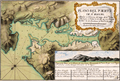
This old map from after 1770 shows Chatham Harbour. It was called Puerto de San Joseph then. You can see the entrance to the harbour with Bald Island (marked as "A") and Mount Weddell in the background.
-
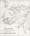
This map from before 1829 by Charles Barnard shows States Bay, States Harbour, and Swan Island. These are now known as Chatham Harbour, States Cove, and Weddell Island.
-
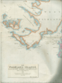
A piece of an 1841 map of the Falkland Islands by John Arrowsmith. It features Swan Island, States Harbour, and Great Harbour, which are now Weddell Island, States Cove, and Gull Harbour.
-
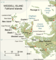
A map of Weddell Island.


