
Loop Head, Weddell Island facts for kids


Loop Head is a special point of land on the eastern side of the entrance to Chatham Harbour. It's located on Weddell Island, which is part of the Falkland Islands. Think of a "head" or "headland" as a piece of land that sticks out into the sea. Loop Head is found at 51°45′48″S 60°53′49″W / 51.76333°S 60.89694°W. This spot is about 2.4 kilometres (1.5 mi) west of Swan Point and 5.5 kilometres (3.4 mi) east-northeast of Beacon Point. It's an important landmark for boats navigating the waters around Weddell Island.
Exploring Weddell Island
Weddell Island is one of the larger islands in the Falkland Islands group. It's known for its beautiful natural scenery and wildlife. The island is named after James Weddell, a British explorer who visited the area a long time ago.
What Makes Loop Head Special?
Loop Head acts like a natural signpost for ships. Its position helps sailors find their way into Chatham Harbour. This harbor provides a safe place for boats to anchor. The Falkland Islands are famous for their strong winds and changing weather. So, having clear landmarks like Loop Head is very helpful for navigation.
Life Around Loop Head
The areas around headlands like Loop Head are often home to many types of wildlife. While this article doesn't list specific animals, the Falkland Islands are famous for penguins, seals, and many kinds of seabirds. These creatures often live along the coastlines. They use the rocky shores and sheltered bays for breeding and finding food.
Gallery
-
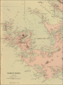
An old map of Weddell Island showing Loop Head
-
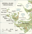
A modern map of Weddell Island


