
Gull Harbour facts for kids


Gull Harbour is a special bay on the east coast of Weddell Island. This island is part of the Falkland Islands. A bay is a part of the sea that curves into the land. Gull Harbour is about 1.3 kilometers (0.8 miles) wide. It stretches 2.8 kilometers (1.7 miles) inland.
You can find Gull Harbour between two points of land. These are Gull Point to the north and Mark Point to the south. The main town on Weddell Island, called Weddell Settlement, is located right at the end of this bay. In the past, Gull Harbour had different names. It was once known as States Harbour and later as Great Harbour until the mid-1800s.
Contents
Gull Harbour: A Special Place
Gull Harbour is an important natural feature of Weddell Island. It provides a sheltered area for boats. This makes it a good spot for the island's main settlement.
Where is Gull Harbour Located?
Gull Harbour is found on the eastern side of Weddell Island. Weddell Island is one of the larger islands in the Falkland Islands group. The Falkland Islands are located in the South Atlantic Ocean. The exact center of Gull Harbour is at 51°53′56″S 60°53′20″W / 51.89889°S 60.88889°W.
What's in Gull Harbour?
The most important place in Gull Harbour is Weddell Settlement. This is the main community on Weddell Island. People live and work here. The bay's calm waters are helpful for daily life and activities on the island.
Images for kids
-
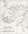
States Bay, States Harbour, Canton Harbour and Swan Island (present Chatham Harbour, States Cove, Gull Harbour and Weddell Island) on a pre 1829 Falklands map by Charles Barnard
-
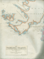
1841 Falkland Islands map by John Arrowsmith, fragment featuring Swan Island, States Harbour and Great Harbour (present Weddell Island, States Cove and Gull Harbour)
-
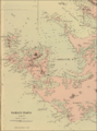
Old map of Weddell Island featuring Gull Harbour
-
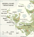
Map of Weddell Island


