
Weddell Settlement facts for kids
Quick facts for kids
Weddell Settlement
|
|
|---|---|
|
Settlement
|
|

Location of Weddell Settlement in the Falkland Islands
|
|

Weddell Settlement
Location in Falkland Islands
|
|
| Country | Falkland Islands |
| Island | Weddell Island |
| Bay | Gull Harbour (formerly Great Harbour) |
| Website | Weddell Island Official Website: http://www.weddellisland.com |

Weddell Settlement is the only town on Weddell Island in the Falkland Islands. It sits on the east coast of the island, at the top of a safe place called Gull Harbour. This harbor used to be known as Great Harbour and is part of Queen Charlotte Bay.
The settlement is located about 12 kilometers (7.5 miles) northeast of Race Point. It's also about 15 kilometers (9.3 miles) south of Swan Point. If you were to travel from Weddell Settlement to Stanley, the capital of the Falkland Islands, it would be about 212 kilometers (132 miles) west-southwest. It's also 56.6 kilometers (35 miles) west of Fox Bay on West Falkland.
Life in Weddell Settlement
Weddell Settlement is the main hub for two important activities on Weddell Island: sheep farming and tourism. It helps manage everything needed for these industries.
Getting Around
- By Sea: The settlement has a 50-meter (164-foot) pier. This is like a long dock where boats can stop to drop off or pick up goods and people.
- By Air: The island's airport is located about 2.7 kilometers (1.7 miles) north of Weddell Settlement. It has two unpaved runways, which means they are made of dirt, not concrete. One runway is 470 meters (1,540 feet) long, and the other is 400 meters (1,300 feet) long. Small planes, like the Britten-Norman Islander aircraft from the Falkland Islands Government Air Service (FIGAS), use this airport. These planes fly from Stanley Airport.
- By Road: There are two main dirt roads on Weddell Island, both starting from Weddell Settlement.
- One road is 13 kilometers (8 miles) long. It goes north towards the airport and continues further north to Loop Head Shanty and then to Loop Head and Swan Point.
- The other road is 15 kilometers (9 miles) long and goes west. It goes around Chatham Harbour and then turns north at Kelp Creek House to reach Chatham House.
New Improvements
The buildings and facilities for tourists and farmers in Weddell Settlement are currently being updated. For example, the Weddell Lodge is being made bigger. This will provide more places for tourists and workers to stay, especially during the busy summer months.
Gallery
-
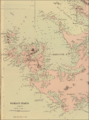
An old map of Weddell Island.
-
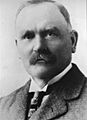
John Hamilton was a sheep farmer whose family owned the settlement and the island from 1923 to 1987.
-

Sheep being gathered on Weddell Island.
-

Lewis Clifton (pictured) and his brother Stephen have owned the island since 2015.
-
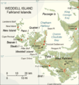
A modern map of Weddell Island.


See also
 In Spanish: Weddell (islas Malvinas) para niños
